Dalälven
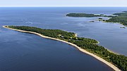
River in SwedenThe Dal River is a river in central Sweden that flows from the north of Dalarna and runs into the sea in northern Uppland; it is commonly considered to be the southern border of Norrland, however only the last part correlates with Limes Norrlandicus. The northern part is split into two rivers: Österdalälven and Västerdalälven. The two connect in Djurås. It is over 520 kilometres (320 mi) long — the second longest river in Sweden, and has a hydropower potential of 1420 megawatts, of which 2/3 is utilized. The largest power plant is located at the Trängslet Dam. Dalälven has been significant historically as a raft transport route. Nedre Dalälven River Landscape, Sweden, covers 308,000 hectares (1,190 sq mi) with a mixture of wetlands, rivers, lakes, flood plains and productive forests. It includes Lake Hovran and Färnebofjärden Bay Ramsar site.
Read article


Top Questions
AI generatedMore questions
Nearby Places

Älvkarleby Municipality
Municipality in Uppsala County, Sweden

Skutskär
Place in Uppland, Sweden

Älvkarleby
Place in Uppland, Sweden
Furuvik
Place in Gästrikland, Sweden
Gårdskär
Place in Uppland, Sweden
Älvkarleby Hydroelectric Power Station
Powerplant in Sweden
Furuvik Zoo
Amusement park and zoo in Furuvik, Sweden
Billudden