Cypress Park, Los Angeles
Neighborhood of Los AngelesCypress Park is a densely populated neighborhood of 10,000+ residents in Northeast Los Angeles, California. Surrounded by hills on three sides, it sits in the valley created by the Los Angeles River and the Arroyo Seco. It is the site of the Rio de Los Angeles State Park, the Los Angeles River Bike Path and other recreational facilities. It hosts one private and four public schools.
Read article


Top Questions
AI generatedMore questions
Nearby Places

Lincoln/Cypress station
Los Angeles Metro Rail station

Heritage Square station
Los Angeles Metro Rail station

Richard Henry Dana Branch
United States historic place

Rio de Los Angeles State Park
State recreation area in Los Angeles, California, United States.
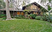
Ernest and Florence Bent Halstead House and Grounds
Historic site in Glenalbyn Drive, Los Angeles
Taylor Yard
Former railroad yard redeveloped as park and housing
Los Angeles River Center and Gardens
Barra Santos
Restaurant in Los Angeles, California, U.S.