Cowden
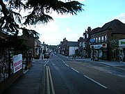
Village in Kent, EnglandCowden is a village and civil parish in the Sevenoaks District of Kent, England. The parish is located on the northern slopes of the Weald, south-west of Tonbridge, and lies close to the borders of both East Sussex and Surrey. It is situated within the High Weald AONB. The old High Street has Grade II listed cottages and village houses, and there is an inn called The Fountain. At the 2011 Census the population of the village was 818.
Read article


Top Questions
AI generatedMore questions
Nearby Places

Cowden railway station
Railway station in Kent, England

Sundridge with Ide Hill
Civil parish in Kent, England

Markbeech
Village in Kent, England

Cowden rail crash
1994 collision in Kent, England
London to Lewes Way
Roman road in England

Queen's Arms, Cowden Pound
Public house in Cowden, Kent
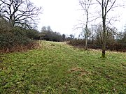
Cowden Meadow
Protected area in Kent, England

St Mary Magdalene, Cowden
Church in England, England