Chipaque Formation
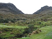
The Chipaque Formation (Spanish: Formación Chipaque, K2cp, Kc) is a geological formation of the Altiplano Cundiboyacense, Eastern Ranges of the Colombian Andes. The formation is also described as Gachetá Formation, named after Gachetá, in the area of the Llanos foothills of the Eastern Ranges. The predominantly organic shale formation dates to the Late Cretaceous period; Cenomanian-Turonian epochs and has a maximum thickness of 1,700 metres (5,600 ft). The formation, rich in TOC, is an important oil and gas generating unit for the giant oilfields Cupiagua and Cusiana of the Eastern Ranges as well as in the Llanos Orientales.
Read article


Top Questions
AI generatedMore questions
Nearby Places

Chipaque
Municipality and town in Cundinamarca, Colombia

Une
Municipality and town in Cundinamarca, Colombia
Sumapaz Páramo

Fómeque Formation
Geological formation in the Colombian Andes

Une Formation
Geological Formation
Rosablanca Formation
Geologic formation in the Andes
Ritoque Formation
Geological formation in the Colombian Andes
Pacho Formation