Map Graph

Chatham Islands

Remote New Zealand archipelago

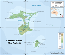
The Chatham Islands are an archipelago in the Pacific Ocean about 800 km (430 nmi) east of New Zealand's South Island, administered as part of New Zealand, and consisting of about 10 islands within an approximate 60 km (30 nmi) radius, the largest of which are Chatham Island and Pitt Island (Rangiauria). They include New Zealand's easternmost point, the Forty-Fours. Some of the islands, formerly cleared for farming, are now preserved as nature reserves to conserve some of the unique flora and fauna.

Read article
File:Chatham_Islands_from_space_ISS005-E-15265.jpgFile:Chatham_Islands_in_New_Zealand_(zoom).svgFile:Chatham-Islands_map_topo_en.svgFile:Schist_formations,_Kaingaroa,_Chatham_Islands.jpgFile:Chatham_islands_forgetmenot.jpgFile:20180930_Chathams_153.jpgFile:Bloom_around_the_Chatham_Islands,_New_Zealand.jpgFile:Chatham_Island_Tree_Carving.JPGFile:Torotoro_Monument_Kaingaroa.jpgFile:Moriori_people.jpgFile:View_from_Chatham_Islands.jpgFile:Landing_approach_to_Tuuta_Airport,_Chatham_Island.jpgFile:Flag_of_Chatham_Islands.svg
Top Questions
AI generated

List the top facts about Chatham Islands

Summarize this article

What is the single most intriguing fact about Chatham Islands?

Are there any controversies surrounding Chatham Islands?

More questions
Timeline
AI Generated
Show full timeline