Charnwood Forest
Upland area in Leicestershire, EnglandCharnwood Forest is a hilly tract in north-western Leicestershire, England, bounded by Leicester, Loughborough and Coalville. The area is undulating, rocky and picturesque, with barren areas. It also has some extensive tracts of woodland; its elevation is generally 600 feet (180 m) and upwards, the area exceeding this height being about 6,100 acres (25 km2). The highest point, Bardon Hill, is 912 feet (278 m). On its western flank lies an abandoned coalfield, with Coalville and other former mining villages, now being regenerated and replanted as part of the National Forest. The M1 motorway, between junctions 22 and 23, cuts through Charnwood Forest.
Read article


Top Questions
AI generatedMore questions
Nearby Places

Newtown Linford
Human settlement in England

Old John
Highest hill in Bradgate Park

Ulverscroft
Civil parish in Leicestershire, England
Ulverscroft Priory
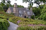
Stoneywell
Historic house, gardens and woodland near Coalville, Leicestershire, England

Benscliffe Wood
Scientific Interest area in Leicestershire

Lea Meadows
Nature reserve in Leicestershire

Rocky Plantation