Map Graph

Cetina

River in Croatia

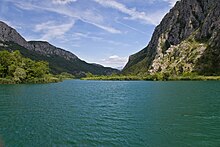
The Cetina is a river in southern Croatia. It has a length of 101 km (63 mi) and its basin covers an area of 1,463 km2 (565 sq mi). From its source, Cetina descends from an elevation of 385 metres (1,263 ft) above sea level to the Adriatic Sea. It is the most water-rich river in Dalmatia.

Read article
File:Cetina_river.jpgFile:The_Eye_of_Cetina_-_cropped.jpgFile:SeeP1030003.JPGFile:Cetina_river_near_Sinj_-_location_Despotuša_-_Croatia_IMG_20210819_182955.jpgFile:Rijeka_Cetina.jpgFile:Cetina_kod_Šestanovca_(Croatia).jpgFile:Cetina_river_view2.jpgFile:Cetina_river_source.jpg
Top Questions
AI generated

List the top facts about Cetina

Summarize this article

What is the single most intriguing fact about Cetina?

Are there any controversies surrounding Cetina?

More questions