Central Croatia
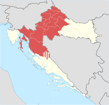
Historical region of CroatiaIn contemporary geography, the terms Central Croatia and Mountainous Croatia are used to describe most of the area sometimes historically known as Croatia or Croatia proper, one of the four historical regions of the Republic of Croatia, together with Dalmatia, Istria, and Slavonia. It is located between Slavonia in the east, the Adriatic Sea in the west, and Dalmatia to the south. The region is not officially defined, and its borders and extent are described differently by various sources. The term Central Croatia refers to the northeastern part, and the term Mountainous Croatia refers to the southwestern part of the territory; the far western part is known as the Croatian Littoral; likewise the terms 'Zagreb macroregion' and 'Rijeka macroregion' can be used instead. Central Croatia is the most significant economic area of the country, contributing well over 50% of Croatia's gross domestic product. The capital of the Republic of Croatia, Zagreb, is the largest city and most important economic centre in Central Croatia.


