Cambridgeshire
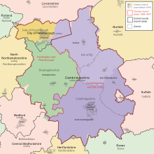
County of EnglandCambridgeshire is a ceremonial county in the East of England and East Anglia. It is bordered by Lincolnshire to the north, Norfolk to the north-east, Suffolk to the east, Essex and Hertfordshire to the south, Northamptonshire to the west, and Bedfordshire to the south-west. The largest settlement is the city of Peterborough, and the city of Cambridge is the county town.
Read article
Top Questions
AI generatedMore questions
Nearby Places

New Bedford River
Watercourse in Cambridgeshire, England

Bluntisham
Village in Cambridgeshire, England

Colne, Cambridgeshire
Village and civil parish in England

List of Sites of Special Scientific Interest in Cambridgeshire
Earith
Village in Cambridgeshire, England

Bluntisham railway station
Disused railway station in Bluntisham, Huntingdonshire
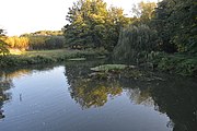
List of local nature reserves in Cambridgeshire

Berry Fen
Neutral grassland in Earith, England

