Burgenland
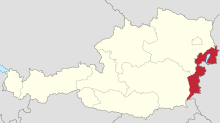
Austrian stateBurgenland is the easternmost and least populous state of Austria. It consists of two statutory cities and seven rural districts, with a total of 171 municipalities. It is 166 km (103 mi) long from north to south but much narrower from west to east. The region is part of the Centrope Project. The name of Burgenland was invented/coined in 1922, after its territories became part of Austria. The population of Burgenland as of 1 January 2024 is 301,951. Burgenland's capital is Eisenstadt.
Read article
Top Questions
AI generatedMore questions
Nearby Places

Draßmarkt
Place in Burgenland, Austria

Kaisersdorf
Place in Burgenland, Austria

Neutal
Place in Burgenland, Austria

Piringsdorf
Place in Burgenland, Austria

Steinberg-Dörfl
Place in Burgenland, Austria

Stoob
Place in Burgenland, Austria

Unterrabnitz-Schwendgraben
Place in Burgenland, Austria
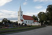
Weingraben
Place in Burgenland, Austria


