Brunei–Muara District
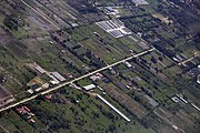
District of BruneiBrunei–Muara District or simply known as Brunei–Muara, is the smallest as well as the most populated district in Brunei. It has an area of 571 square kilometres (220 sq mi) and the population of 318,530 as of 2021. The district is also home to its administrative centre is Bandar Seri Begawan, as well as the Brunei International Airport and Muara Port, the country's only international airport and deep-water port respectively. The Brunei River flows within this district and is home to Kampong Ayer. As the administrative center of Brunei is located in the district, it remains the most developed in the country with the most up-to-date infrastructure, despite not being the center of Brunei's main economic activity.
Read article


.jpg)


Top Questions
AI generatedMore questions
Nearby Places

Seri Mulia Sarjana School
Mukim Pengkalan Batu
Mukim in Brunei-Muara, Brunei
Sultan Sharif Ali Islamic University
National university in Brunei
Duli Pengiran Muda Al-Muhtadee Billah College
College in Gadong, Brunei

Kampong Beribi
Village in Brunei-Muara, Brunei

Kampong Mata-Mata
Village in Brunei-Muara, Brunei
Kampong Perpindahan Mata-Mata
Village and public housing estate in Brunei-Muara, Brunei
IBTE Business Campus
Campus in Gadong 'B'