Brailes
Human settlement in EnglandBrailes is a civil parish about 3 miles (5 km) east of Shipston-on-Stour in Warwickshire, England. It includes the two villages of Lower and Upper Brailes which are located in the north Cotswolds, but it is often referred to as one village as the two villages adjoin each other. The parish includes the village of Winderton about 1.5 miles (2.4 km) northeast of Brailes, and the deserted medieval village of Chelmscote about 3.5 miles (5.6 km) north of Brailes. The parish is bounded to the east by Ditchedge Lane and Beggars' Lane, which are a historic ridgeway that also forms part of the county boundary with Oxfordshire. The northeastern boundary is a minor road, part of which follows the course of a Roman road.
Read article


Top Questions
AI generatedMore questions
Nearby Places
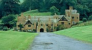
Compton Wynyates
Country house
Shipston-on-Stour Rural District
Rural district of Worcestershire and later Warwickshire

Cherington, Warwickshire
Village and civil parish in England

Traitor's Ford
Ford on the River Stour in Warwickshire, England

Evolution of Worcestershire county boundaries since 1844

Stourton, Warwickshire
Human settlement in England
Compton Wynyates (parish)
Parish in Warwickshire, England

Sutton-under-Brailes
Village in Warwickshire, England