Botlek
Seaport of Rotterdam, NetherlandsThe Botlek originally was the name of a stretch of the Nieuwe Maas river, part of the Rhine–Meuse delta near the Dutch cities of Vlaardingen and Spijkenisse in the province of South Holland. Specifically, it was the name of the strait that separated the island of Rozenburg from the sand bar of Welplaat. The strait itself was merely the continuation of the Nieuwe Maas, and the stretch of the river south of Rozenburg continued to be called Nieuwe Maas until the confluence with Het Scheur formed the Brielse Maas estuary.
Read article

.jpg)
_IMG_2507_2022-07-11_12.34.jpg)
_IMG_2515_2022-07-11_12.48.jpg)

Top Questions
AI generatedMore questions
Nearby Places

Geervliet
Town in South Holland province, Netherlands
Langebakkersoord
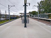
Vlaardingen West metro station
Metro station in Vlaardingen, the Netherlands

Oude Maas
Distributary of the Rhine River in South Holland, Netherlands

Nieuwe Maas
River in South Holland, the Netherlands
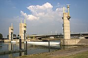
Hartelkering
Storm surge barrier in the Netherlands
Vondelingenplaat
Neighborhood of Rotterdam in South Holland, Netherlands

Carmarthen Borough Council
Former borough of Carmarthenshire, Wales