Battert
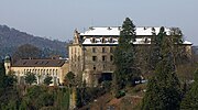
The Battert is a hill, 567.9 m above sea level (NHN), on the western edge of the Northern Black Forest north of Baden-Baden in Germany. On its western slopes are the ruins of Hohenbaden Castle, on the southern side is the climbing area and nature reserve called the Battert Rocks (Battertfelsen). On the hill ridge are the remains of a circular rampart, probably built by Celtic settlers. On the eastern side lies the village of Ebersteinburg.
Read article


_Baden-Baden.JPG)


Top Questions
AI generatedMore questions
Nearby Places
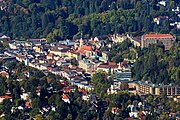
Baden-Baden
Spa town in Baden-Württemberg, Germany

Festspielhaus Baden-Baden
Opera and concert hall in Baden-Baden, Germany

Merkur Funicular Railway

Alt Eberstein
Hardberg (Schwarzwald)
Mountain of Baden-Württemberg, Germany

Ebersteinburg
Ortsteil of Baden-Baden in Baden-Württemberg, Germany

Friedrichsbad
Baden-Baden bath
New Castle (Baden-Baden)