Basin, Montana
Census-designated place in Montana, United StatesBasin is an unincorporated community and census-designated place (CDP) in Jefferson County, Montana, United States. It lies approximately 10 miles (16 km) southeast of the Continental Divide in a high narrow canyon along Interstate 15 about halfway between Butte and Helena. Basin Creek flows roughly north to south through Basin and enters the Boulder River on the settlement's south side. The population was 212 at the 2010 census, down from 255 at the 2000 census.
Read article


_2_(17182999341).jpg)


Top Questions
AI generatedMore questions
Nearby Places
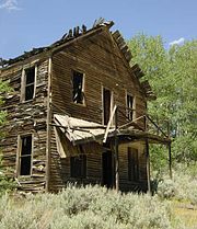
Comet, Montana
Ghost town in Montana, United States