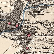
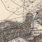
Al-Kabri
Place in Acre, Mandatory PalestineAl-Kabri was a Palestinian Arab town in the Galilee located 12.5 kilometers (7.8 mi) northeast of Acre. It was captured by the Haganah 21 May 1948, a week after the State of Israel was declared. In 1945, it had a population of 1,530 and a total area cultivated of 20,617 dunams. It is near the site of Tel Kabri.
Read article
.jpg)
.jpg)
.jpg)
.jpg)
.jpg)


.jpg)
Top Questions
AI generatedMore questions
Nearby Places

Al-Nahr
Place in Acre, Mandatory Palestine
Al-Ghabisiyya
Place in Acre, Mandatory Palestine
Al-Tall, Acre
Village in Acre, Mandatory Palestine
Al-Kabri massacre
1948 Israeli military operation

Kabri, Israel
Kibbutz in northern Israel
Ben Ami
Place in Northern, Israel

Netiv HaShayara
Place in Northern, Israel

Tel Kabri
Archaeological tell in Israel containing a large Canaanite palace dated to the Middle Bronze Age