Aguada, Puerto Rico
Town and municipality in Puerto RicoAguada, originally San Francisco de Asís de la Aguada, is a town and municipality of Puerto Rico, located in the northwestern coastal valley region bordering the Atlantic Ocean, east of Rincón, south of Aguadilla, west of Moca; and north of Añasco and Mayagüez. It is part of the Aguadilla-Isabela-San Sebastián Metropolitan Statistical Area. Aguada's population is spread over 17 barrios and Aguada Pueblo.
Read article


.svg)


Top Questions
AI generatedMore questions
Nearby Places
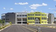
Aguada Coliseum
Arena in Aguada, Puerto Rico
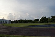
Aguada Stadium
Sports venue in Aguada, Puerto Rico
Playa Espinar
Beach in Puerto Rico

Aguada barrio-pueblo
Historical and administrative center (seat) of Aguada, Puerto Rico

Asomante, Aguada, Puerto Rico
Barrio of Puerto Rico

Piedras Blancas, Aguada, Puerto Rico
Barrio of Puerto Rico

Guaniquilla, Aguada, Puerto Rico
Barrio of Puerto Rico

Church of San Francisco de Asís
Church in Aguada, Puerto Rico