Schierling
Municipality in Bavaria, Germany From Wikipedia, the free encyclopedia
Municipality in Bavaria, Germany From Wikipedia, the free encyclopedia
Schierling is a municipality in the district of Regensburg in Bavaria, Germany.
Schierling | |
|---|---|
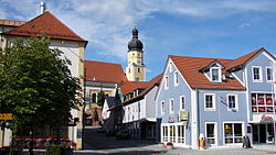
 Town square with the Church of Saints Peter and Paul | |
Location of Schierling within Regensburg district  | |
| Coordinates: 48°50′05″N 12°08′23″E | |
| Country | Germany |
| State | Bavaria |
| Admin. region | Oberpfalz |
| District | Regensburg |
| Subdivisions | 16 Ortsteile |
| Government | |
| • Mayor (2020–26) | Christian Kiendl[1] (CSU) |
| Area | |
| • Total | 77.62 km2 (29.97 sq mi) |
| Elevation | 381 m (1,250 ft) |
| Population (2023-12-31)[2] | |
| • Total | 8,532 |
| • Density | 110/km2 (280/sq mi) |
| Time zone | UTC+01:00 (CET) |
| • Summer (DST) | UTC+02:00 (CEST) |
| Postal codes | 84069 |
| Dialling codes | 09451 |
| Vehicle registration | R |
| Website | www.schierling.de |
The municipality is an important industrial location and the southernmost in the Upper Palatinate.
At the gates of Schierling, Napoleon and his allies defeated the Austrians in the Battle of Eckmühl. As early as the time of Otto the Great, he moved into his headquarters in Schierling during the siege of Regensburg on the Via Claudia Augusta, the road built by the Romans and named after their emperor Augustus.
Seamless Wikipedia browsing. On steroids.
Every time you click a link to Wikipedia, Wiktionary or Wikiquote in your browser's search results, it will show the modern Wikiwand interface.
Wikiwand extension is a five stars, simple, with minimum permission required to keep your browsing private, safe and transparent.