Top Qs
Timeline
Chat
Perspective
Yazd province
Province of Iran From Wikipedia, the free encyclopedia
Remove ads
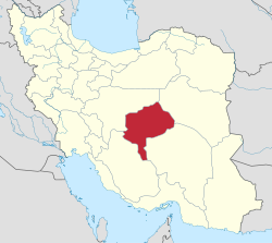
Yazd province (Persian: استان یزد)[a] is one of the 31 provinces of Iran and is in the center of the country. Its capital is the city of Yazd.[4] In 2014, it was placed in Region 5.[5] The province has an area of 76,469 km2.
Remove ads
Demographics
Summarize
Perspective
Population
At the time of the 2006 National Census, the province's population was 958,323 in 258,691 households.[6] The 2011 national census counted 1,074,428 people living in 309,749 households.[7] The 2016 census measured the population of the province as 1,138,533 in 340,657 households, by which time Tabas County had been separated from the province to join South Khorasan province.[2]
Administrative divisions
The population history and structural changes of Yazd Province's administrative divisions over three consecutive censuses are shown in the following table.
Cities
According to the 2016 census, 971,355 people (over 85% of the population of Yazd province) live in the following cities:[2]
Remove ads
Geography

Yazd Province with the area of 129,285 km2 (49,917 sq mi)[12] is situated in an oasis where the Dasht-e Kavir desert and the Dasht-e Lut desert meet. The city itself is sometimes called "the bride of the Kavir" because of its location, in a valley between Shir Kuh, the tallest mountain in the region at 4,075 m (13,369 ft) above sea level, and Kharaneq. The city proper is located at 1,203 m (3,947 ft) above sea-level, and covers 16,000 km2 (6,200 sq mi).
Mountains of Yazd
- South- and Southwestern Mountains
This group is wider than the other ridges and includes Shir Kuh
- Eastern Mountains
They are located in the east of Yazd Province with the highest peaks being Bon Lokht (3002)
Remove ads
Gallery


See also
![]() Media related to Yazd Province at Wikimedia Commons
Media related to Yazd Province at Wikimedia Commons
Notes
- Separated from Bafq County after the 2006 census[8]
- Separated from Khatam County after the 2016 census[9]
- Transferred to South Khorasan Province after the 2011 census[10]
- Separated from Yazd County after the 2016 census[11]
References
Wikiwand - on
Seamless Wikipedia browsing. On steroids.
Remove ads


