Ümraniye
District and municipality in Istanbul, Turkey From Wikipedia, the free encyclopedia
District and municipality in Istanbul, Turkey From Wikipedia, the free encyclopedia
Ümraniye (pronounced [ymˈɾaːnije]) is a municipality and district of Istanbul Province, Turkey.[2] Its area is 46 km2,[3] and its population is 723,760 (2023).[1] It was separated from Üsküdar in 1987. It is bordered by Çekmeköy to the northeast, Sancaktepe to the east, Ataşehir to the south, Üsküdar to the west and Beykoz to the northwest.
Ümraniye | |
|---|---|
District and municipality | |
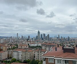
 A landscape of Ümraniye, Istanbul | |
 Map showing Ümraniye District in Istanbul Province | |
| Coordinates: 41°01′52″N 29°06′29″E | |
| Country | Turkey |
| Province | Istanbul |
| Government | |
| • Mayor | İsmet Yıldırım (AKP) |
| Area | 46 km2 (18 sq mi) |
| Population (2023)[1] | 723,760 |
| • Density | 16,000/km2 (41,000/sq mi) |
| Time zone | UTC+3 (TRT) |
| Area code | 0216 |
| Website | www |
Ümraniye is located on high ground just inland from Üsküdar. It was originally a small village of less than 900 inhabitants, mainly coming from the Black Sea Region in the 1950s. Its population grew far beyond its capacity during the 1970s and 1980s due to migration to the cities from rural areas of Anatolia. On 17 March 1978, 5 workers were massacred by Communist militants in the district.
The growth of Ümraniye was relatively better controlled than other districts that also attracted workers on the European side (such as Esenler or Gaziosmanpaşa); there are wider roads through the district, more space between the blocks and relatively more green space. A large commercial district grew up to support this large population. The main road through the centre has public buildings, shops, shopping centres and branches of many banks.
There are 37 neighbourhoods in Ümraniye District:[4]

In the last few decades, Ümraniye has built a lively shopping and business district. Recent building projects include the construction of large shopping malls (including Istanbul's first branch of IKEA), and modern apartment complexes have made parts of Ümraniye attractive places buying real estate, as Ümraniye is on a main highway that leads to one of the two bridges linking the Asian and European sides of Istanbul.

The women's football club Dudullu Spor was promoted to the Women's First League for the 2020-21 League season.[5]
The Süper Lig club Ümraniyespor is located in Ümraniye. The club plays their matches in the Ümraniye Belediyesi Şehir Stadium.
Ümraniye has seen its fair share of political violence between left and right-wingers over the years, and during the 70s and 80s law enforcement was problematic in parts of the area. In this way it was considered the Asian side's equivalent of Gaziosmanpaşa on the European side. This violence was concentrated in a small quarter of Ümraniye, a vast district. In recent times however, Ümraniye has been relatively calm. The people of Ümraniye usually vote in large numbers for conservative parties. The AK Party does well in this district.

In between Üsküdar and Ümraniye there is a 'çilehane' of the Sufi saint Aziz Mahmud Hudayi. A çilehane (lit. 'house of despair') was where Sufis would go to pray in seclusion.
The Haldun Alagaş Sports Hall is located here, which is named after the karateka Haldun Alagaş. The venue hosts both national and international basketball, volleyball, handball games and martial art competitions.[6]
Due to its elevated altitude, the full scene of Istanbul, including Bosphorus and European Side, can be seen from Ümraniye.
Ümraniye is twinned with:
Seamless Wikipedia browsing. On steroids.
Every time you click a link to Wikipedia, Wiktionary or Wikiquote in your browser's search results, it will show the modern Wikiwand interface.
Wikiwand extension is a five stars, simple, with minimum permission required to keep your browsing private, safe and transparent.