Uqturpan County
County in Xinjiang, China From Wikipedia, the free encyclopedia

Uqturpan County[5][6][7] or Uchturpan County[8][9][10] (transliterated from Uyghur: ئۇچتۇرپان ناھىيىسى; Chinese: 乌什吐鲁番县), also Wushi County (Chinese: 乌什县), is a county in the Xinjiang Uyghur Autonomous Region under the administration of Aksu Prefecture and shares an approximately 150 km (93 mi)[2][clarification needed] long border with Kyrgyzstan's Issyk-Kul Region. The county is bordered to the northeast by Onsu County (Wensu), to the southeast by Aksu city, to the west by Akqi County in Kizilsu Kyrgyz Autonomous Prefecture and to the south by Kalpin County (Keping). It has an area of 9,012 square kilometres (3,480 sq mi) and as of the 2002 census[update] a population of 180,000.
Uqturpan County
Uchturpan, Wushi, Uch Turfan, Wushih | |
|---|---|
.png) Location of Uqturpan County (red) within Aksu Prefecture (yellow) and Xinjiang | |
 Uqturpan Location of the seat in Xinjiang  Uqturpan Uqturpan (China) | |
| Coordinates: 41°12′50″N 79°13′23″E | |
| Country | China |
| Autonomous region | Xinjiang |
| Prefecture | Aksu |
| County seat | Uqturpan Town (Wushi) |
| Township-level divisions | 3 towns, 6 townships[1] |
| Area | |
• Total | 9,051.54 km2 (3,494.82 sq mi) |
| Elevation | 1,200–2,000 m (3,937–6,561 ft) |
| Population (2020)[3] | |
• Total | 205,571 |
| • Density | 23/km2 (59/sq mi) |
| Ethnic groups | |
| • Major ethnic groups | Uyghur[4] |
| Time zone | UTC+8 (China Standard[a]) |
| Postal code | 843400 |
| Website | www |
| Uqturpan County | |||||||||||
|---|---|---|---|---|---|---|---|---|---|---|---|
| Uyghur name | |||||||||||
| Uyghur | ئۇچتۇرپان ناھىيىسى | ||||||||||
| |||||||||||
| Chinese name | |||||||||||
| Simplified Chinese | 乌什县 | ||||||||||
| Traditional Chinese | 烏什縣 | ||||||||||
| |||||||||||
| Alternative Chinese name | |||||||||||
| Simplified Chinese | 乌什吐鲁番县 | ||||||||||
| Traditional Chinese | 烏什吐魯番縣 | ||||||||||
| |||||||||||
Name
Uqturpan is also spelled Uchturpan and Uch-Turfan.[11]
History
Summarize
Perspective
Tang
During the Battle of Aksu (717), the Umayyad Caliphate and their Turgesh and Tibetan Empire allies hope to seize Uqturpan (then known as Dai-dʑiᴇk-dʑiᴇŋ) from Tang-Karluks-Exiled Western Turkic Khaganate allies but were repelled.[12]
Qing

Ush Turfan was the site of a battle between Barhanuddin and Abdulla during the Revolt of the Altishahr Khojas.[13][self-published source][14] Six years after the Revolt of the Altishahr Khojas, ten years after the Qing's rescue of the Khoja Brothers from Dzungars, an anti-Qing uprising of the local Turkic (later "Uyghur") people took place in Uqturpan. Legend says that a local rebel leader was married to Iparhan, known as the "Fragrant Concubine" a descendant of Apaq Khoja. During the turmoil, many fled, and the thousands who remained were killed by Sino-Manchu forces. Later, the area was repopulated by migrants from what is now Southern Xinjiang.[15]
The Ush rebellion in 1765 by Uyghurs against the Manchus occurred after Uyghur women were gang raped by the servants and son of Manchu official Su-cheng.[16] It was said that Ush Muslims had long wanted to sleep on [Sucheng and son's] hides and eat their flesh. because of the rape of Uyghur Muslim women for months by the Manchu official Sucheng and his son.[17] The Manchu Emperor ordered that the Uyghur rebel town be massacred, the Qing forces enslaved all the Uyghur children and women and slaughtered the Uyghur men.[18] Manchu soldiers and Manchu officials regularly having sex with or raping Uyghur women caused massive hatred and anger by Uyghur Muslims to Manchu rule.[19]
21st century
.jpg)
In 2012, Aqyar Township (Aheya) was made a town.[20]

In a 2012 article from Radio Free Asia, it was reported that according to family sources and local authorities, Islam Urayim, then 32, a native of Uqturpan County who had been deported to China on December 19, 2009, despite seeking asylum in Cambodia, had been sentenced to life in prison. It was unclear when Urayim was sentenced or on what charges he was convicted.[22]
On April 3, 2015, Imam Township (Yimamu) was made a town.[23]
On October 27, 2019, at 1:29 PM, a 5.0-magnitude earthquake hit Uqturpan County. No casualties were reported.[5]
According to a 2020 Radio Free Asia report, it was estimated by local officials that 20,000 Uyghurs were detained in the three re-education camps in the county.[24]
Geography
The highest point in Uqturpan County is Zhatekelie Feng (扎特克列峰) at 5,135 m (16,847 ft) above sea level.[2]
59.9% of the territory of Uqturpan County is mountainous, 27.6% is Gobi-like desert areas and 12.5% is valley flatland.[2]
Administrative divisions
Uqturpan County administered 3 towns, 5 townships and 1 ethnic townships:[25][1][20]
| Name | Simplified Chinese | Hanyu Pinyin | Uyghur (UEY) | Uyghur Latin (ULY) | Administrative division code | Notes | |
|---|---|---|---|---|---|---|---|
| Towns | |||||||
| Uqturpan Town (Wushi Town) |
乌什镇 | Wūshí Zhèn | ئۇچتۇرپان بازىرى | Uchturpan baziri | 652927100 | ||
| Aqyar Town[26] (Aheya, Akyar;[27] | 阿合雅镇 | Āhéyǎ Zhèn | ئاقيار بازىرى | Aqyar baziri | 652927101 | ||
| Imam Town[28] | 依麻木镇 | Yīmámù Zhèn | ئىمام بازىرى | Imam baziri | 652927102 | formerly Imam Township (依麻木乡) | |
| Townships | |||||||
| Aqtoqay Township | 阿克托海乡 | Ākètuōhǎi Xiāng | ئاقتوقاي يېزىسى[29] | Aqtoqay yëzisi | 652927200 | ||
| Yakowruk Township[30] | 亚科瑞克乡 | Yàkēruìkè Xiāng | ياكۆۋرۈك يېزىسى[31] | yaköwrük yëzisi | 652927201 | ||
| Achatagh Township | 阿恰塔格乡 | Āqiàtǎgé Xiāng | ئاچاتاغ يېزىسى[32] | Achatagh yëzisi | 652927202 | ||
| Yengiawat Township[33] | 英阿瓦提乡 | Yīng'āwǎtí Xiāng | يېڭىئاۋات يېزىسى | yëngi'awat yëzisi | 652927205 | ||
| Otbeshi Township | 奥特贝希乡 | Àotèbèixī Xiāng | ئوتبېشى يېزىسى[34] | Otbëshi yëzisi | 652927207 | ||
| Ethnic township | |||||||
| Yamansu Kyrgyz Ethnic Township | 亚曼苏柯尔克孜族乡 | Yàmànsū Kē'ěrkèzīzú Xiāng | يامانسۇ قىرغىز يېزىسى | yamansu qirghiz yëzisi | 652927206 | (Kyrgyz) جامانسۇۇ قىرعىز ايىلى Жаман-Суу Кыргыз айылы | |
Climate
| Climate data for Uqturpan, elevation 1,396 m (4,580 ft), (1991–2020 normals, extremes 1981–2010) | |||||||||||||
|---|---|---|---|---|---|---|---|---|---|---|---|---|---|
| Month | Jan | Feb | Mar | Apr | May | Jun | Jul | Aug | Sep | Oct | Nov | Dec | Year |
| Record high °C (°F) | 9.7 (49.5) |
14.5 (58.1) |
27.1 (80.8) |
31.5 (88.7) |
32.7 (90.9) |
35.7 (96.3) |
36.9 (98.4) |
35.4 (95.7) |
34.2 (93.6) |
27.5 (81.5) |
20.1 (68.2) |
16.9 (62.4) |
36.9 (98.4) |
| Mean daily maximum °C (°F) | −2.0 (28.4) |
3.8 (38.8) |
12.5 (54.5) |
20.6 (69.1) |
24.8 (76.6) |
27.9 (82.2) |
29.6 (85.3) |
28.5 (83.3) |
24.3 (75.7) |
17.7 (63.9) |
8.2 (46.8) |
−0.1 (31.8) |
16.3 (61.4) |
| Daily mean °C (°F) | −9.0 (15.8) |
−2.7 (27.1) |
6.0 (42.8) |
13.7 (56.7) |
17.6 (63.7) |
20.7 (69.3) |
22.2 (72.0) |
21.3 (70.3) |
16.9 (62.4) |
9.6 (49.3) |
1.3 (34.3) |
−6.4 (20.5) |
9.3 (48.7) |
| Mean daily minimum °C (°F) | −15.0 (5.0) |
−8.6 (16.5) |
0.0 (32.0) |
6.9 (44.4) |
10.8 (51.4) |
13.9 (57.0) |
15.3 (59.5) |
14.7 (58.5) |
10.4 (50.7) |
3.2 (37.8) |
−3.6 (25.5) |
−11.2 (11.8) |
3.1 (37.5) |
| Record low °C (°F) | −26.6 (−15.9) |
−27.3 (−17.1) |
−15.1 (4.8) |
−3.4 (25.9) |
1.3 (34.3) |
4.7 (40.5) |
8.1 (46.6) |
6.0 (42.8) |
−0.2 (31.6) |
−4.5 (23.9) |
−12.3 (9.9) |
−23.4 (−10.1) |
−27.3 (−17.1) |
| Average precipitation mm (inches) | 2.2 (0.09) |
4.8 (0.19) |
5.7 (0.22) |
10.3 (0.41) |
16.5 (0.65) |
24.2 (0.95) |
23.9 (0.94) |
27.8 (1.09) |
23.5 (0.93) |
4.0 (0.16) |
2.5 (0.10) |
2.2 (0.09) |
147.6 (5.82) |
| Average precipitation days (≥ 0.1 mm) | 3.2 | 2.6 | 2.0 | 2.9 | 5.9 | 7.9 | 9.0 | 9.7 | 6.3 | 1.8 | 1.5 | 2.5 | 55.3 |
| Average snowy days | 6.3 | 3.7 | 1.9 | 0.3 | 0 | 0 | 0 | 0 | 0 | 0 | 2.0 | 5.3 | 19.5 |
| Average relative humidity (%) | 71 | 63 | 51 | 44 | 48 | 52 | 56 | 59 | 63 | 64 | 70 | 75 | 60 |
| Mean monthly sunshine hours | 170.9 | 187.9 | 217.7 | 244.8 | 282.7 | 294.7 | 312.8 | 286.0 | 260.2 | 248.1 | 185.0 | 152.6 | 2,843.4 |
| Percentage possible sunshine | 57 | 62 | 58 | 60 | 62 | 65 | 69 | 68 | 71 | 74 | 64 | 54 | 64 |
| Source: China Meteorological Administration[35][36] | |||||||||||||
Demographics
| Year | Pop. | ±% p.a. |
|---|---|---|
| 2000 | 177,410 | — |
| 2010 | 197,990 | +1.10% |
| [20] | ||
As of 2015, 216,579 of the 235,336 residents of the county were Uyghur, 11,462 were Han Chinese, 5,613 were Kyrgyz and 1,682 were from other ethnic groups.[37]
As of 1999, 90.01% of the population of Uqturpan (Wushi) County was Uyghur and 6.73% of the population was Han Chinese.[38]
Economy
Uqturpan County's economy is primarily based on agriculture and animal husbandry, producing wheat, rice, corn, cotton, sesame (胡麻), rapeseed, and pelts. Industries include cooking oil processing, tractor repair, and construction among others.[39]
As of 1885[update], there was about 86,800 acres (572,793 mu) of cultivated land in Uqturpan.[40]
Historical maps
Historical English-language maps including Uqturpan:
 Map including Uqturpan (labeled as Uch Turfan) (1917)
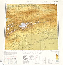 Map including Uqturpan (labeled as WU-SHIH (UCH TURFAN)) and surrounding region from the International Map of the World (AMS, 1950)[b]
 Map including Uqturpan (labeled as WU-SHIH (UCH TURFAN)) (DMA, 1973)
 Map including Uqturpan (labeled as Wushi) (DMA, 1981)
_p61_PLATE19._SINKIANG_(14597194848).jpg)
_-_panoramio.jpg)


Notes
- Locals in Xinjiang frequently observe UTC+6 (Xinjiang Time), 2 hours behind Beijing.
References
Wikiwand - on
Seamless Wikipedia browsing. On steroids.