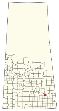
The Rural Municipality of Wolseley No. 155 (2016 population: 372) is a rural municipality (RM) in the Canadian province of Saskatchewan within Census Division No. 5 and SARM Division No. 1. it is located in the southeast portion of the province.
Wolseley No. 155 | |
|---|---|
| Rural Municipality of Wolseley No. 155 | |
 Grain elevators in Wolseley | |
 Location of the RM of Wolseley No. 155 in Saskatchewan | |
| Coordinates: 50.518°N 103.173°W[1] | |
| Country | Canada |
| Province | Saskatchewan |
| Census division | 5 |
| SARM division | 1 |
| Formed[2] | December 13, 1909 |
| Government | |
| • Reeve | Bev Kenny |
| • Governing body | RM of Wolseley No. 155 Council |
| • Administrator | Rose Zimmer |
| • Office location | Wolseley |
| Area (2016)[4] | |
| • Land | 774.26 km2 (298.94 sq mi) |
| Population (2016)[4] | |
| • Total | 372 |
| • Density | 0.5/km2 (1/sq mi) |
| Time zone | CST |
| • Summer (DST) | CST |
| Area code(s) | 306 and 639 |
History
The RM of Wolseley No. 155 incorporated as a rural municipality on December 13, 1909.[2]
Geography
Wolf Creek flows through the RM.[5] The narrowleaf water plantain (alisma gramineum}, tall larkspur (delphinium glaucum), and common butterwort (pinguicula vulgaris) are species of special concern in this area.[6]
Communities and localities
The following urban municipalities are surrounded by the RM.
The following unincorporated communities are within the RM.
- Localities
- Adair
- Ellisboro
- Falcon
- Grainer
- Summerberry, dissolved as a village, December 31, 1972
Demographics
In the 2021 Census of Population conducted by Statistics Canada, the RM of Wolseley No. 155 had a population of 366 living in 143 of its 166 total private dwellings, a change of -1.6% from its 2016 population of 372. With a land area of 758.46 km2 (292.84 sq mi), it had a population density of 0.5/km2 (1.2/sq mi) in 2021.[9]
In the 2016 Census of Population, the RM of Wolseley No. 155 recorded a population of 372 living in 151 of its 178 total private dwellings, a -8.1% change from its 2011 population of 405. With a land area of 774.26 km2 (298.94 sq mi), it had a population density of 0.5/km2 (1.2/sq mi) in 2016.[4]
Government
The RM of Wolseley No. 155 is governed by an elected municipal council and an appointed administrator that meets on the third Monday of every month.[3] The reeve of the RM is Bev Kenny while its administrator is Rose Zimmer.[3] The RM's office is located in Wolseley.[3]
Transportation
Highway 1 (the Trans-Canada Highway) bisects the RM.
See also
References
Wikiwand in your browser!
Seamless Wikipedia browsing. On steroids.
Every time you click a link to Wikipedia, Wiktionary or Wikiquote in your browser's search results, it will show the modern Wikiwand interface.
Wikiwand extension is a five stars, simple, with minimum permission required to keep your browsing private, safe and transparent.
