Top Qs
Timeline
Chat
Perspective
Rural Municipality of White Valley No. 49
Rural municipality in Saskatchewan, Canada From Wikipedia, the free encyclopedia
Remove ads
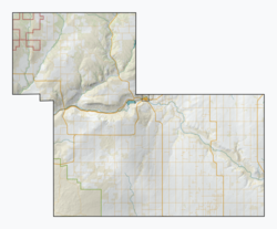
The Rural Municipality of White Valley No. 49 (2016 population: 478) is a rural municipality (RM) in the Canadian province of Saskatchewan within Census Division No. 4 and SARM Division No. 3. It is located in the southwest portion of the province near Eastend.
Remove ads
Remove ads
History
The RM of White Valley No. 49 incorporated as a rural municipality on January 1, 1913.[2]
Geography
Communities and localities
The following urban municipalities are surrounded by the RM.
The following unincorporated communities are within the RM.
- Localities[5]
- Bench
- Chambery
- East Fairwell
- Klintonel
- Knollys
- Neighbour
- Olga
- Ravenscrag
Demographics
In the 2021 Census of Population conducted by Statistics Canada, the RM of White Valley No. 49 had a population of 352 living in 146 of its 182 total private dwellings, a change of -26.4% from its 2016 population of 478. With a land area of 2,001.56 km2 (772.81 sq mi), it had a population density of 0.2/km2 (0.5/sq mi) in 2021.[8]
In the 2016 Census of Population, the RM of White Valley No. 49 recorded a population of 478 living in 155 of its 195 total private dwellings, a 0% change from its 2011 population of 478. With a land area of 2,026.88 km2 (782.58 sq mi), it had a population density of 0.2/km2 (0.6/sq mi) in 2016.[4]
Government
The RM of White Valley No. 49 is governed by an elected municipal council and an appointed administrator that meets on the second Thursday of every month.[3] The reeve of the RM is James Leroy while its administrator is Tracey Schacher.[3] The RM's office is located in Eastend.[3]
Transportation
See also
References
Wikiwand - on
Seamless Wikipedia browsing. On steroids.
Remove ads


