Verkhoyansky District
District in Sakha Republic, Russia From Wikipedia, the free encyclopedia
District in Sakha Republic, Russia From Wikipedia, the free encyclopedia
Verkhoyansky District (Russian: Верхоя́нский улу́с; Yakut: Үөһээ Дьааҥы улууһа, Üöhee Caaŋı uluuha, IPA: [ˈyøheː ɟaːŋɯ uluːha]) is an administrative[1] and municipal[6] district (raion, or ulus), one of the thirty-four in the Sakha Republic, Russia. It is located in the northern central part of the republic and borders with Ust-Yansky District in the northeast, Momsky District in the east, Tomponsky District in the south, Kobyaysky District in the southwest, Eveno-Bytantaysky National District in the west, and with Bulunsky District in the northwest. The area of the district is 137,400 square kilometers (53,100 sq mi).[3] Its administrative center is the urban locality (a settlement) of Batagay.[3] Population: 12,815 (2010 Census);[4] 13,666 (2002 Census);[9] 24,259 (1989 Soviet census).[10] The population of Batagay accounts for 34.1% of the district's total population.[4]
Verkhoyansky District
Верхоянский улус | |
|---|---|
| Other transcription(s) | |
| • Sakha | Үөһээ Дьааҥы улууhа |
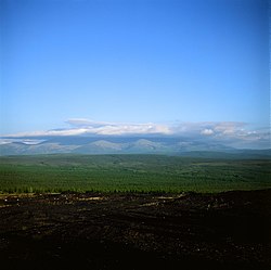
 Mat-Gora, Verkhoyansky District | |
 Location of Verkhoyansky District in the Sakha Republic | |
| Coordinates: 67°33′N 133°23′E | |
| Country | Russia |
| Federal subject | Sakha Republic[1] |
| Established | January 5, 1967[2] |
| Administrative center | Batagay[3] |
| Area | |
| • Total | 137,400 km2 (53,100 sq mi) |
| Population | |
| • Total | 12,815 |
| • Density | 0.093/km2 (0.24/sq mi) |
| • Urban | 46.2% |
| • Rural | 53.8% |
| Administrative structure | |
| • Administrative divisions | 1 Towns under district jurisdiction, 2 Settlements, 14 Rural okrugs |
| • Inhabited localities[3] | 1 cities/towns, 2 Urban-type settlements[5], 26 rural localities |
| Municipal structure | |
| • Municipally incorporated as | Verkhoyansky Municipal District[6] |
| • Municipal divisions[7] | 3 urban settlements, 14 rural settlements |
| Time zone | UTC+10 (MSK+7 |
| OKTMO ID | 98616000 |
| Website | https://mr-verhojanskij.sakha.gov.ru/ |
The main river in the district is the Yana and its tributaries Nelgese, Derbeke, Tykakh and Baky.[11]
Average January temperature ranges from −48 °C (−54 °F) to −38 °C (−36 °F) and average July temperature ranges from +16 °C (61 °F) to +17 °C (63 °F). Annual precipitation ranges from 150 to 300 millimeters (5.9 to 11.8 in).[2]
The district was established on January 5, 1967.[2]
As of the 2021 Census, the ethnic composition was as follows:[12]
The economy of the district is mostly based on agriculture.[2] There are deposits of tin, tungsten, copper, lead, antimony, gold, silver, brown coal, and other minerals.
| Towns | Population | Male | Female | Inhabited localities in jurisdiction |
|---|---|---|---|---|
| Verkhoyansk (Верхоянск) |
1311 | 611 (46.6%) | 700 (53.4%) |
|
| Urban settlements | Population | Male | Female | Inhabited localities in jurisdiction |
| Batagay (Батагай) |
2756 | 1403 (50.9%) | 1455 (49.1%) |
|
| Ese-Khayya (Эсэ-Хайя) |
239 | 120 (50.2%) | 119 (49.8%) | |
| Rural settlements | Population | Male | Female | Rural localities in jurisdiction* |
| Adychchinsky Nasleg (Адыччинский наслег) |
526 | 248 (47.1%) | 278 (52.9%) |
|
| Arylakhsky Nasleg (Арылахский наслег) |
559 | 283 (50.6%) | 276 (49.4%) | |
| Babushkinsky Nasleg (Бабушкинский наслег) |
373 | 193 (51.7%) | 180 (48.3%) | |
| Barylassky Nasleg (Барыласский наслег) |
103 | 55 (53.4%) | 48 (46.6%) |
|
| Borulakhsky Nasleg (Борулахский наслег) |
737 | 383 (52.0%) | 354 (48.0%) | |
| Dulgalakhsky Nasleg (Дулгалахский наслег) |
326 | 177 (54.3%) | 149 (45.7%) |
|
| Sartansky Nasleg (Сартанский наслег) |
629 | 314 (49.9%) | 315 (50.1%) |
|
| Stolbinsky Nasleg (Столбинский наслег) |
318 | 158 (49.7%) | 160 (50.3%) |
|
| Suordakhsky Nasleg (Суордахский наслег) |
354 | 177 (50.0%) | 177 (50.0%) |
|
| Tabalakhsky Nasleg (Табалахский наслег) |
1018 | 501 (49.2%) | 517 (50.8%) |
|
| Chyoryumchinksy Nasleg (Чёрюмчинский наслег) |
223 | 126 (56.5%) | 97 (43.5%) |
|
| Eginsky Nasleg (Эгинский наслег) |
700 | 336 (48.0%) | 364 (52.0%) | |
| Elgessky Nasleg (Эльгесский наслег) |
404 | 200 (49.5%) | 204 (50.5%) |
|
| Yansky Nasleg (Янский наслег) |
212 | 95 (44.8%) | 117 (55.2%) |
Divisional source:[13]
Population source:[4]
*Administrative centers are shown in bold
Seamless Wikipedia browsing. On steroids.
Every time you click a link to Wikipedia, Wiktionary or Wikiquote in your browser's search results, it will show the modern Wikiwand interface.
Wikiwand extension is a five stars, simple, with minimum permission required to keep your browsing private, safe and transparent.