Klippan Municipality
Municipality in Skåne County, Sweden From Wikipedia, the free encyclopedia
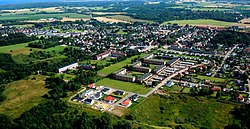
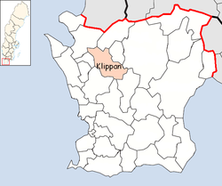
Klippan Municipality (Swedish: Klippans kommun) is a municipality in Skåne County in southern Sweden. Its seat is located in the town of Klippan.
Klippan Municipality
Klippans kommun | |
|---|---|
 | |
 | |
| Coordinates: 56°08′N 13°08′E | |
| Country | Sweden |
| County | Skåne County |
| Seat | Klippan |
| Area | |
| • Total | 379.41 km2 (146.49 sq mi) |
| • Land | 374.32 km2 (144.53 sq mi) |
| • Water | 5.09 km2 (1.97 sq mi) |
| Area as of 1 January 2014. | |
| Population (31 December 2023)[2] | |
| • Total | 17,723 |
| • Density | 47/km2 (120/sq mi) |
| Time zone | UTC+1 (CET) |
| • Summer (DST) | UTC+2 (CEST) |
| ISO 3166 code | SE |
| Province | Scania |
| Municipal code | 1276 |
| Website | www |
The municipality was created in 1974 through the amalgamation of the market town Klippan (itself instituted in 1945) with the rural municipality of Riseberga and part of Östra Ljungby.
Söderåsen National Park is partly situated within the municipality.
Localities
There were five localities in the municipality in 2018.[3]
| Locality | Population |
|---|---|
| Klippan | 8,819 |
| Ljungbyhed | 2,168 |
| Östra Ljungby | 1,819 |
| Klippans bruk | 319 |
| Krika | 196 |
Demographics
This is a demographic table based on Klippan Municipality's electoral districts in the 2022 Swedish general election sourced from SVT's election platform, in turn taken from SCB official statistics.[4]
In total there were 17,742 residents, including 12,988 Swedish citizens of voting age.[4] 33.6% voted for the left coalition and 64.7% for the right coalition. Indicators are in percentage points except population totals and income.
| Location | Residents | Citizen adults |
Left vote | Right vote | Employed | Swedish parents |
Foreign heritage |
Income SEK |
Degree |
|---|---|---|---|---|---|---|---|---|---|
| % | % | ||||||||
| Klippan N-Gråmanstorp | 1,708 | 1,207 | 37.5 | 60.8 | 74 | 66 | 34 | 20,729 | 27 |
| Klippan NÖ-Solslätt | 1,680 | 1,202 | 37.0 | 62.0 | 78 | 73 | 27 | 23,484 | 29 |
| Klippan SÖ-Nyslätt | 2,266 | 1,667 | 35.9 | 61.8 | 71 | 73 | 27 | 20,850 | 23 |
| Klippan V | 2,107 | 1,496 | 37.4 | 60.5 | 70 | 64 | 36 | 19,950 | 26 |
| Krika-Bonnarp | 1,363 | 997 | 28.5 | 70.9 | 83 | 81 | 19 | 27,632 | 27 |
| Ljungbyhed N | 1,440 | 1,078 | 32.7 | 66.2 | 70 | 79 | 21 | 20,946 | 27 |
| Ljungbyhed S | 1,268 | 972 | 32.3 | 66.5 | 76 | 85 | 15 | 21,989 | 32 |
| Riseberga-Färingtofta | 1,258 | 986 | 34.1 | 64.6 | 77 | 84 | 16 | 23,404 | 37 |
| Stidsvig | 995 | 696 | 32.6 | 65.4 | 80 | 79 | 21 | 24,801 | 27 |
| Storäng-Vedby | 2,101 | 1,581 | 30.9 | 67.5 | 86 | 86 | 14 | 26,815 | 30 |
| Östra Ljungby | 1,556 | 1,106 | 29.0 | 69.0 | 78 | 79 | 21 | 23,065 | 23 |
| Source: SVT[4] | |||||||||
Buildings
The Church of St. Peter, designed by Sigurd Lewerentz, was completed in 1966.[5]
References
External links
Wikiwand in your browser!
Seamless Wikipedia browsing. On steroids.
Every time you click a link to Wikipedia, Wiktionary or Wikiquote in your browser's search results, it will show the modern Wikiwand interface.
Wikiwand extension is a five stars, simple, with minimum permission required to keep your browsing private, safe and transparent.

