Västervik Municipality
Municipality in Kalmar County, Sweden From Wikipedia, the free encyclopedia
Västervik Municipality (Swedish: Västerviks kommun) is a municipality in Kalmar County, south-eastern Sweden, with its seat in the city of Västervik.
Västervik Municipality
Västerviks kommun | |
|---|---|
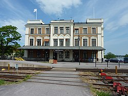
 Västervik Railway Station | |
 | |
| Coordinates: 57°45′N 16°38′E | |
| Country | Sweden |
| County | Kalmar County |
| Seat | Västervik |
| Area | |
• Total | 3,596.85 km2 (1,388.75 sq mi) |
| • Land | 1,874.43 km2 (723.72 sq mi) |
| • Water | 1,722.42 km2 (665.03 sq mi) |
| Area as of 1 January 2014. | |
| Population (31 December 2024)[2] | |
• Total | 36,447 |
| • Density | 10/km2 (26/sq mi) |
| Time zone | UTC+1 (CET) |
| • Summer (DST) | UTC+2 (CEST) |
| ISO 3166 code | SE |
| Province | Småland |
| Municipal code | 0883 |
| Website | www.vastervik.se |
The present municipality was created in 1971, when the former City of Västervik was amalgamated with eight surrounding rural municipalities.
Localities

There are 11 urban areas (also called localities, Swedish: tätorter) in Västervik Municipality.
In the table the localities are listed according to the size of the population as of December 31, 2005. The municipal seat is in bold characters.
Demographics
Summarize
Perspective
This is a demographic table based on Västervik Municipality's electoral districts in the 2022 Swedish general election sourced from SVT's election platform, in turn taken from SCB official statistics.[3]
In total there were including 36,704 residents, including 29,293 Swedish citizens of voting age.[3] 48.2 % voted for the left coalition and 50.3 % for the right coalition. Indicators are in percentage points except population totals and income.
| Location | Residents | Citizen adults |
Left vote | Right vote | Employed | Swedish parents |
Foreign heritage |
Income SEK |
Degree |
|---|---|---|---|---|---|---|---|---|---|
| % | % | ||||||||
| Blackstad-Odensvi | 1,283 | 1,034 | 42.6 | 56.2 | 85 | 94 | 6 | 22,940 | 29 |
| Brevik | 1,556 | 1,225 | 50.5 | 48.6 | 83 | 89 | 11 | 26,246 | 44 |
| Centrum | 1,783 | 1,663 | 45.4 | 53.8 | 82 | 88 | 12 | 24,957 | 44 |
| Djurgården-Törnfall | 1,833 | 1,410 | 41.2 | 57.5 | 85 | 91 | 9 | 28,806 | 50 |
| Gamleby 1 | 1,927 | 1,500 | 46.8 | 51.2 | 74 | 83 | 17 | 19,342 | 26 |
| Gamleby 2-Lofta | 1,838 | 1,436 | 42.8 | 54.9 | 79 | 88 | 12 | 22,614 | 29 |
| Gladhammar-Västrum | 1,668 | 1,269 | 47.8 | 50.0 | 76 | 81 | 19 | 21,799 | 30 |
| Hallingeberg S | 1,343 | 1,034 | 52.4 | 46.3 | 76 | 83 | 17 | 20,985 | 25 |
| Hjorted | 1,319 | 1,030 | 51.9 | 46.7 | 80 | 88 | 12 | 21,744 | 29 |
| Jenny-Kvännaren | 1,772 | 1,316 | 43.9 | 54.8 | 89 | 91 | 9 | 27,758 | 40 |
| Johannesdal | 2,093 | 1,627 | 55.0 | 43.1 | 78 | 78 | 22 | 23,689 | 33 |
| Karstorp | 1,705 | 1,360 | 56.2 | 41.3 | 70 | 72 | 28 | 19,105 | 25 |
| Loftahammar | 749 | 661 | 44.2 | 54.9 | 80 | 92 | 8 | 21,613 | 33 |
| Ludvigsdal-Hornslandet | 1,930 | 1,512 | 48.3 | 50.5 | 87 | 90 | 10 | 27,169 | 40 |
| Marieborg | 1,505 | 1,231 | 50.4 | 48.0 | 81 | 87 | 13 | 23,619 | 42 |
| Peru | 1,255 | 1,011 | 48.7 | 49.1 | 80 | 84 | 16 | 23,671 | 35 |
| Piperskärr-Gränsö | 1,817 | 1,497 | 37.4 | 61.7 | 84 | 92 | 8 | 30,637 | 51 |
| Skogshaga | 2,077 | 1,588 | 56.7 | 42.3 | 78 | 82 | 18 | 23,743 | 33 |
| Södermalm | 1,482 | 1,145 | 56.7 | 40.8 | 69 | 69 | 31 | 19,179 | 31 |
| Ukna-Västra Ed | 1,254 | 1,040 | 45.5 | 52.8 | 77 | 92 | 8 | 19,602 | 31 |
| Västralund-Stenhagen | 1,603 | 1,322 | 47.5 | 51.1 | 85 | 93 | 7 | 26,526 | 42 |
| Östermalm | 1,487 | 1,231 | 54.0 | 45.1 | 80 | 85 | 15 | 23,661 | 37 |
| Överum | 1,425 | 1,151 | 47.5 | 50.3 | 74 | 86 | 14 | 19,920 | 19 |
| Source: SVT[3] | |||||||||
International relations
Twin towns — Sister cities
The municipality is twinned with:[4]
References
External links
Wikiwand - on
Seamless Wikipedia browsing. On steroids.

