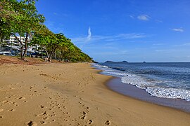
Trinity Beach, Queensland
Suburb of Cairns, Queensland, Australia From Wikipedia, the free encyclopedia
Suburb of Cairns, Queensland, Australia From Wikipedia, the free encyclopedia
Trinity Beach is a coastal suburb of Cairns in the Cairns Region, Queensland, Australia.[2] In the 2021 census, Trinity Beach had a population of 6,594 people.[1]
| Trinity Beach Cairns, Queensland | |||||||||||||||
|---|---|---|---|---|---|---|---|---|---|---|---|---|---|---|---|
 Trinity Beach looking north | |||||||||||||||
 | |||||||||||||||
| Coordinates | 16.7933°S 145.6966°E | ||||||||||||||
| Population | 6,594 (2021 census)[1] | ||||||||||||||
| • Density | 767/km2 (1,986/sq mi) | ||||||||||||||
| Postcode(s) | 4879 | ||||||||||||||
| Area | 8.6 km2 (3.3 sq mi) | ||||||||||||||
| Time zone | AEST (UTC+10:00) | ||||||||||||||
| Location |
| ||||||||||||||
| LGA(s) | Cairns Region | ||||||||||||||
| State electorate(s) | Barron River | ||||||||||||||
| Federal division(s) | Leichhardt | ||||||||||||||
| |||||||||||||||


Trinity Beach is approximately 20 kilometres (10 mi) from the Cairns city centre and approximately 6.6 km from Smithfield. Trinity Beach is also a beach stretching for about a mile on the eastern coast of Australia bounded by the Coral Sea.[3] The suburb itself is approximately 2 km wide.

Trinity Beach is situated in the Djabugay (Tjapukai) traditional Aboriginal country. [4]
The origin of the suburb name is derived from Trinity Bay.[5]
From 1943 to 1944, Trinity Beach was the site of intensive training in amphibious warfare for Australian and American troops in the context of World War II.[6]
Trinity Beach State School opened on 30 January 1979.[7]
As part of Mulgrave Shire, Trinity Beach experienced suburban development beginning in the 1970s,[8] leading to a population of over 2000 by the mid-1980s.[9]
Trinity Beach became part of the new City of Cairns with the amalgamation of Mulgrave Shire into the new city on 22 March 1995.[10]
In 2000, Cyclone Steve, which made landfall in the Cairns northern beaches area near Trinity Beach,[11] caused significant damage to the roof of the Trinity Beach Hotel.[12]
From 2004 to 2008, the 173-ha Bluewater subdivision,[13] which extends through both Trinity Beach and Trinity Park, was approved for development.[14] As with several other areas in Trinity Beach, portions of the estate sit in a flood zone[15] due to potential inflows from Moore's Gully, which led to a substantial flooding mitigation project for the development in 2010.[16]

In 2023, Trinity Beach was affected by Cyclone Jasper and the resulting 2023 Cairns floods. On 13 December, as the cyclone made landfall, the Trinity Beach waterfront experienced a storm surge event,[17] while soon after overnight, multiple waterfront businesses were vandalised and looted.[18][19]
On the morning of 17 December, like other Cairns northern beaches suburbs, Trinity Beach experienced flooding. This flooding led to an evacuation warning for the Bluewater Estate[20][21] and major road closures,[22][23] which resulted in isolation from the rest of Cairns.[24] Videos on social media soon emerged showing inundated residential neighbourhoods in the suburb. The beach itself was thickly covered with debris in the aftermath of the flooding.[25]
In the 2011 census, Trinity Beach had a population of 4,734 people.[26]
In the 2016 census, Trinity Beach had a population of 5,488 people.[27]
In the 2021 census, Trinity Beach had a population of 6,594 people.[1]
Trinity Beach State School is a government primary (Prep-6) school for boys and girls at Wewak Street (16.7948°S 145.6895°E).[28][29] It includes a special education program.[28] In 2016, the school had an enrolment of 923 students with 60 teaching staff (57 full-time equivalent) and 36 non-teaching staff (22 full-time equivalent).[30] In 2018, the school had an enrolment of 1,027 students with 68 teachers (64 full-time equivalent) and 49 non-teaching staff (32 full-time equivalent).[31]
There are no secondary schools in Trinity Beach. The nearest government secondary school is Smithfield State High School in neighbouring Smithfield to the south.[32]
Trinity Beach Community Hall is at 51 Trinity Beach Road (16.78940°S 145.69424°E). As at April 2024, a new community hall is under construction by the Cairns Regional Council.[33]
Seamless Wikipedia browsing. On steroids.
Every time you click a link to Wikipedia, Wiktionary or Wikiquote in your browser's search results, it will show the modern Wikiwand interface.
Wikiwand extension is a five stars, simple, with minimum permission required to keep your browsing private, safe and transparent.