Xinhe County, Xinjiang
County in Xinjiang, China From Wikipedia, the free encyclopedia

Xinhe County (Chinese: 新和县) as the official romanized name, also formerly known as its Uyghur name Toksu County[7] (Uyghur: توقسۇ ناھىيىسى;[8] Chinese: 托克苏县), is a county in Aksu Prefecture, Xinjiang Uyghur Autonomous Region, China.
Xinhe County
Toksu, Hsin-ho | |
|---|---|
.png) Location of Toksu County (red) within Aksu Prefecture (yellow) and Xinjiang | |
 Xinhe County Location of the seat  Xinhe County Xinhe County (China) | |
| Coordinates: 41°33′01″N 82°37′00″E | |
| Country | China |
| Autonomous region | Xinjiang |
| Prefecture | Aksu |
| County seat | Toksu Town (Xinhe) |
| Area | |
• Total | 5,820.46 km2 (2,247.29 sq mi) |
| Population (2020)[4] | |
• Total | 194,473 |
| • Density | 33/km2 (87/sq mi) |
| Ethnic groups | |
| • Major ethnic groups | Uyghur[5][6] |
| Time zone | UTC+8 (China Standard[a]) |
| Website | xjxinhe |
| Xinhe County, Xinjiang | |||||||||||
|---|---|---|---|---|---|---|---|---|---|---|---|
| Uyghur name | |||||||||||
| Uyghur | توقسۇ ناھىيىسى | ||||||||||
| |||||||||||
| Chinese name | |||||||||||
| Simplified Chinese | 新和县 | ||||||||||
| Traditional Chinese | 新和縣 | ||||||||||
| |||||||||||
| Alternative Chinese name | |||||||||||
| Simplified Chinese | 托克苏县 | ||||||||||
| Traditional Chinese | 托克蘇縣 | ||||||||||
| |||||||||||
Name
The county's original name Toksu was changed into Xinhe in 1941. "Xinhe" is the abbreviation of "Xinjiang Heping" (新疆和平), literally "Xinjiang Peace."[3][9]
History
On October 27, 1930, Toksu County was created from part of Kuqa.[3][9]
In 1941[9] or 1944,[3] Toksu County's Chinese character name was changed from 'Tuokesu' County (托克蘇縣) to 'Xinhe' County (新和縣).
Administrative divisions
Xinhe County administered 4 towns, 4 townships and 4 other areas:[10][2][11]
| Name | Simplified Chinese | Hanyu Pinyin | Uyghur (UEY) | Uyghur Latin (ULY) | Administrative division code | Notes | |
|---|---|---|---|---|---|---|---|
| Towns | |||||||
| Toksu Town (Xinhe Town) |
新和镇 | Xīnhé Zhèn | توقسۇ بازىرى | toqsu baziri | 652925100 | ||
| Yultuzbaġ Town[12] | 尤鲁都斯巴格镇 | Yóulǔdūsībāgé Zhèn | يۇلتۇزباغ بازىرى | yultuzbagh baziri | 652925101 | formerly Yultuzbaġ Township (尤鲁都斯巴格乡) | |
| Icheriq Town | 依其艾日克镇 | Yīqí'àirìkè Zhèn | ئىچئېرىق بازىرى | Ich'ëriq baziri | 652925102 | formerly Icheriq Township (依其艾日克乡) | |
| Tasheriq Town | 塔什艾日克镇 | Tǎshí'àirìkè Zhèn | تاشئېرىق بازىرى | tash'ëriq baziri | 652925103 | formerly Tasheriq Township (تاشئېرىق يېزىسى / 塔什艾日克乡) | |
| Payxambabazar Town[13] | 排先拜巴扎镇 | Páixiānbàibāzhā Zhèn | پەيشەنبەبازار بازىرى | peyshenbebazar baziri | 652925104 | formerly Payxambabazar Township (پەيشەنبەبازار يېزىسى / 排先拜巴扎乡) | |
| Üchqat Town | 玉奇喀特镇 | Yùqíkātè Zhèn | ئۈچقات بازىرى | Üchqat baziri | 652925105 | formerly Üchqat Township (ئۈچقات يېزىسى / 玉奇喀特乡) | |
| Townships | |||||||
| Ogen Township | 渭干乡 | Wèigàn Xiāng | ئۆگەن يېزىسى | Ögen yëzisi | 652925203 | ||
| Tamtoghraq Township | 塔木托格拉克乡 | Tǎmùtuōgélākè Xiāng | تامتوغراق يېزىسى | tamtoghraq yëzisi | 652925205 | ||
Climate
| Climate data for Xinhe, elevation 1,010 m (3,310 ft), (1991–2020 normals, extremes 1981–2010) | |||||||||||||
|---|---|---|---|---|---|---|---|---|---|---|---|---|---|
| Month | Jan | Feb | Mar | Apr | May | Jun | Jul | Aug | Sep | Oct | Nov | Dec | Year |
| Record high °C (°F) | 7.5 (45.5) |
14.7 (58.5) |
25.5 (77.9) |
34.7 (94.5) |
35.5 (95.9) |
37.7 (99.9) |
40.5 (104.9) |
38.6 (101.5) |
35.7 (96.3) |
29.8 (85.6) |
21.2 (70.2) |
9.9 (49.8) |
40.5 (104.9) |
| Mean daily maximum °C (°F) | −1.0 (30.2) |
5.9 (42.6) |
14.6 (58.3) |
22.8 (73.0) |
27.5 (81.5) |
31.0 (87.8) |
32.3 (90.1) |
31.0 (87.8) |
26.7 (80.1) |
19.9 (67.8) |
10.3 (50.5) |
0.8 (33.4) |
18.5 (65.3) |
| Daily mean °C (°F) | −7.4 (18.7) |
−0.8 (30.6) |
7.9 (46.2) |
15.9 (60.6) |
20.5 (68.9) |
24 (75) |
25.2 (77.4) |
23.9 (75.0) |
19.1 (66.4) |
11.2 (52.2) |
2.6 (36.7) |
−5.0 (23.0) |
11.4 (52.6) |
| Mean daily minimum °C (°F) | −12.7 (9.1) |
−6.6 (20.1) |
1.6 (34.9) |
9.3 (48.7) |
13.8 (56.8) |
17.3 (63.1) |
18.8 (65.8) |
17.6 (63.7) |
12.4 (54.3) |
4.6 (40.3) |
−2.8 (27.0) |
−9.3 (15.3) |
5.3 (41.6) |
| Record low °C (°F) | −24.0 (−11.2) |
−24.2 (−11.6) |
−10.9 (12.4) |
−1.7 (28.9) |
1.4 (34.5) |
6.7 (44.1) |
10.6 (51.1) |
8.1 (46.6) |
3.6 (38.5) |
−4.7 (23.5) |
−14.1 (6.6) |
−23.6 (−10.5) |
−24.2 (−11.6) |
| Average precipitation mm (inches) | 2.0 (0.08) |
2.8 (0.11) |
1.4 (0.06) |
2.7 (0.11) |
8.2 (0.32) |
16.8 (0.66) |
13.3 (0.52) |
11.2 (0.44) |
7.1 (0.28) |
3.5 (0.14) |
3.0 (0.12) |
1.7 (0.07) |
73.7 (2.91) |
| Average precipitation days (≥ 0.1 mm) | 2.8 | 1.7 | 0.9 | 1.5 | 2.8 | 6.3 | 7.3 | 6.0 | 3.4 | 1.2 | 1.2 | 2.4 | 37.5 |
| Average snowy days | 5.1 | 2.0 | 0.4 | 0.2 | 0 | 0 | 0 | 0 | 0 | 0 | 1.2 | 4.8 | 13.7 |
| Average relative humidity (%) | 70 | 59 | 45 | 38 | 39 | 44 | 49 | 53 | 57 | 60 | 64 | 73 | 54 |
| Mean monthly sunshine hours | 177.6 | 193.4 | 225.5 | 247.5 | 288.0 | 296.5 | 301.9 | 287.1 | 263.5 | 255.5 | 201.2 | 163.4 | 2,901.1 |
| Percentage possible sunshine | 59 | 63 | 60 | 61 | 64 | 65 | 66 | 68 | 72 | 76 | 69 | 58 | 65 |
| Source: China Meteorological Administration[14][15] | |||||||||||||
Economy
The economy is based on agriculture and also animal husbandry. The county produces wheat, corn, rice, cotton and melons as well as Parthian fennel and thin-shelled walnuts. Industries include wool-spinning, knitting, and carpet making.[3]
Demographics
| Year | Pop. | ±% p.a. |
|---|---|---|
| 2000 | 139,806 | — |
| 2010 | 172,064 | +2.10% |
| [2] | ||
As of 2015, 184,399 of the 195,920 residents of the county were Uyghur, 10,901 were Han Chinese and 620 were from other ethnic groups.[5]
According to the 2002 census, it has a population of 140,000.[citation needed]
As of 1999, 95.01% of the population of the county were Uyghur and 4.81% of the population was Han Chinese.[16]
Transportation
Xinhe is served by the Southern Xinjiang Railway.
Historical maps
Historical English-language maps including Toksu/Xinhe:
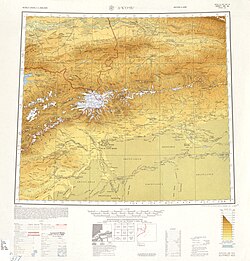 Map including Hsin-ho (Torpak Bazar) and surrounding region from the International Map of the World (AMS, 1950)[b]
 Map including Xinhe (DMA, 1981)
_-_panoramio.jpg)


Notes
- Locals in Xinjiang frequently observe UTC+6 (Xinjiang Time), 2 hours behind Beijing.
References
Wikiwand - on
Seamless Wikipedia browsing. On steroids.