Thomas Glacier
Glacier in Ellsworth Land, Antarctica From Wikipedia, the free encyclopedia
Glacier in Ellsworth Land, Antarctica From Wikipedia, the free encyclopedia
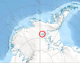
Thomas Glacier (78°40′S 84°0′W) is a roughly Z-shaped glacier which drains the southeast slopes of Vinson Massif and flows for 17 nautical miles (31 km) through the south part of the Sentinel Range, Ellsworth Mountains, leaving the range between Doyran and Petvar Heights south of Johnson Spur.
| Thomas Glacier | |
|---|---|
 Location of Sentinel Range in Western Antarctica. | |
Location of Thomas Glacier in Antarctica | |
| Location | Vinson Massif Sentinel Range |
| Coordinates | 78°40′S 84°0′W |
| Length | 17 nmi (31 km; 20 mi) |
| Thickness | unknown |
| Status | unknown |

The glacier was discovered by U.S. Navy Squadron VX-6 on photographic flights of 14–15 December 1959, and mapped by United States Geological Survey (USGS) from the photos. It was named by Advisory Committee on Antarctic Names (US-ACAN) for R. Admiral Charles W. Thomas, USCG, veteran of Antarctic expeditions in the 1950s.[citation needed]
Seamless Wikipedia browsing. On steroids.
Every time you click a link to Wikipedia, Wiktionary or Wikiquote in your browser's search results, it will show the modern Wikiwand interface.
Wikiwand extension is a five stars, simple, with minimum permission required to keep your browsing private, safe and transparent.