Tawonga
Town in Victoria, Australia From Wikipedia, the free encyclopedia
Tawonga is a town in northeast Victoria, Australia. The town is on the Kiewa Valley Highway, in the Alpine Shire local government area, 350 kilometres (217 mi) northeast of the state capital, Melbourne. At the 2021 census, Tawonga had a population of 568.[2]
| Tawonga Victoria | |||||||||
|---|---|---|---|---|---|---|---|---|---|
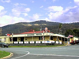
 The Bogong Hotel at Tawonga (destroyed by fire in 2011)[1] | |||||||||
| Coordinates | 36°38′0″S 147°06′0″E | ||||||||
| Population | 568 (2021 census)[2] | ||||||||
| Postcode(s) | 3697 | ||||||||
| Elevation | 330 m (1,083 ft) | ||||||||
| Location |
| ||||||||
| LGA(s) | Alpine Shire | ||||||||
| State electorate(s) | Benambra | ||||||||
| Federal division(s) | Indi | ||||||||
| |||||||||
Tawonga Post Office opened on 4 October 1879.[3]
December 5th 2011 the Country Fire Authority was alerted of a fire at the 125 year old Bogong pub. The building was destroyed.[citation needed]
References
Wikiwand in your browser!
Seamless Wikipedia browsing. On steroids.
Every time you click a link to Wikipedia, Wiktionary or Wikiquote in your browser's search results, it will show the modern Wikiwand interface.
Wikiwand extension is a five stars, simple, with minimum permission required to keep your browsing private, safe and transparent.

