Salajka
Urban neighborhood in South Bačka, Vojvodina, Serbia From Wikipedia, the free encyclopedia

Salajka (Serbian: Салајка), also known as Slavija (Serbian: Славија), is an urban neighborhood of the city of Novi Sad, Serbia.

Borders

The western and southern border of Salajka is Kisačka ulica (Kisač Street), the eastern border is Temerinska ulica (Temerin Street), and the northern border is Danube-Tisa-Danube channel.
Neighbouring city quarters
The neighbouring city quarters are: Podbara in the east, Stari Grad in the south, Rotkvarija in the south-west, Banatić, Pervazovo Naselje and Industrijska Zona Jug in the west, and Vidovdansko Naselje in the north, across the channel.
History
Between 1980 and 1989, the seat of the Slavija municipality, one of the former seven municipalities of Novi Sad City, was located in Salajka.
Sport
The play ground of the football club "Slavija" is located in Salajka.
Gallery
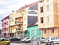 Salajka, Karađorđeva street
 Salajka, Temerinska street
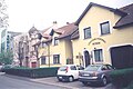 Salajka, Jovana Cvijića street
 Spiritual Church of Christ in Salajka


See also
References
External links
Wikiwand - on
Seamless Wikipedia browsing. On steroids.