Sainte-Aurélie, Quebec
Municipality in Quebec, Canada From Wikipedia, the free encyclopedia
Municipality in Quebec, Canada From Wikipedia, the free encyclopedia
Sainte-Aurélie (French pronunciation: [sɛ̃t oʁeli]) is a municipality in the Les Etchemins Regional County Municipality in the Chaudière-Appalaches region of Quebec, Canada. Its population is 856 as of the Canada 2021 Census. It is named after Sister Sainte-Aurélie, an Ursuline nun at the end of the 19th century.
Sainte-Aurélie | |
|---|---|
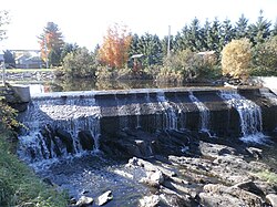
 Dam over Abenaquis Lake. | |
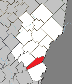
 Location within Les Etchemins RCM. | |
| Coordinates: 46°11′N 70°22′W[1] | |
| Country | |
| Province | |
| Region | Chaudière-Appalaches |
| RCM | Les Etchemins |
| Constituted | April 3, 1909 |
| Government | |
| • Mayor | Gilles Gaudet |
| • Federal riding | Beauce |
| • Prov. riding | Beauce-Sud |
| Area | |
| • Total | 79.90 km2 (30.85 sq mi) |
| • Land | 78.25 km2 (30.21 sq mi) |
| Population (2021)[3] | |
| • Total | 856 |
| • Density | 10.9/km2 (28/sq mi) |
| • Pop 2016-2021 | |
| • Dwellings | 507 |
| Time zone | UTC−5 (EST) |
| • Summer (DST) | UTC−4 (EDT) |
| Postal code(s) | |
| Area code(s) | 418 and 581 |
| Highways | |
| Website | www |
Sainte-Aurélie has a small border crossing to the United States of America, Ste. Aurelie Station.
Sainte-Aurélie was founded by a Frenchman named Victor Vanier in 1909. It was originally known as Metgermette-Nord and was created by separating from what would become Saint-Zacharie. It would be in 1932 that Metgermette-Nord would take its current name of Sainte-Aurélie
Seamless Wikipedia browsing. On steroids.
Every time you click a link to Wikipedia, Wiktionary or Wikiquote in your browser's search results, it will show the modern Wikiwand interface.
Wikiwand extension is a five stars, simple, with minimum permission required to keep your browsing private, safe and transparent.