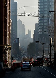
Saint Urbain Street
Thoroughfare in Montreal, Canada From Wikipedia, the free encyclopedia
Thoroughfare in Montreal, Canada From Wikipedia, the free encyclopedia
Saint Urbain Street (French: rue Saint-Urbain) is a major one-way street located in Montreal, Quebec, Canada. The original, southernmost section of the street was built by Urbain Tessier (c. 1624–1689), a farmer and carpenter who settled in the area. The name also makes reference to Saint Urbain.
 Saint Urbain Street in Downtown Montreal. | |
| Native name | rue Saint-Urbain (French) |
|---|---|
| Location | Montreal |
| South end | Saint-Antoine Street, Old Montreal |
| Major junctions | |
| North end | Gouin Boulevard, Ahuntsic |
| Construction | |
| Inauguration | 1817 |
In the late 18th and early 19th centuries, the street, now stretching northward, was home to several of Montreal's prominent British and French merchants, notably the explorer Alexander Henry the elder. By the turn of the 20th century, sections of the street were industrialised and became run down, and were settled by Jews, predominantly from Eastern Europe. Writer Mordecai Richler immortalised the Mile End section as a centre of the Jewish community in Montreal, and he documented the life there in novels such as St. Urbain's Horseman.[1]
From roughly 1970 onwards, the Jewish community uprooted to Outremont and the street was settled by Greek, Portuguese and Caribbean immigrants.[2] Today, much of the street has been gentrified.
Place-d'Armes station is located on the street while the Place-des-Arts station and De Castelnau station are right nearby.
It traverses the boroughs of Ville-Marie, Le Plateau-Mont-Royal, Rosemont–La Petite-Patrie, Villeray–Saint-Michel–Parc-Extension and Ahuntsic-Cartierville.
Seamless Wikipedia browsing. On steroids.
Every time you click a link to Wikipedia, Wiktionary or Wikiquote in your browser's search results, it will show the modern Wikiwand interface.
Wikiwand extension is a five stars, simple, with minimum permission required to keep your browsing private, safe and transparent.