Saint-Michel-Tubœuf
Commune in Normandy, France From Wikipedia, the free encyclopedia
Saint-Michel-Tubœuf (French pronunciation: [sɛ̃ miʃɛl tybœf]) is a commune in the Orne department in north-western France.[3] The commune was formed in 1965 by the merger of the former communes Saint-Michel-la-Forêt and Tubœuf.[4]
Saint-Michel-Tubœuf | |
|---|---|
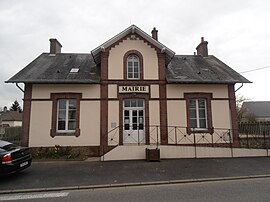
 The town hall in Saint-Michel-Tubœuf | |
| Coordinates: 48°45′10″N 0°41′23″E | |
| Country | France |
| Region | Normandy |
| Department | Orne |
| Arrondissement | Mortagne-au-Perche |
| Canton | L'Aigle |
| Intercommunality | Pays de l'Aigle |
| Government | |
| • Mayor (2020–2026) | Christophe Pottier[1] |
Area 1 | 8.73 km2 (3.37 sq mi) |
| Population (2022)[2] | 576 |
| • Density | 66/km2 (170/sq mi) |
| Time zone | UTC+01:00 (CET) |
| • Summer (DST) | UTC+02:00 (CEST) |
| INSEE/Postal code | 61432 /61300 |
| Elevation | 198–241 m (650–791 ft) (avg. 230 m or 750 ft) |
| 1 French Land Register data, which excludes lakes, ponds, glaciers > 1 km2 (0.386 sq mi or 247 acres) and river estuaries. | |
Points of Interest
National heritage sites
The Commune has two buildings and areas listed as a Monument historique[5]
Château de Thubeuf is a seventeenth century chateau and grounds, that was classed as a Monument historique in 1992.[6]
Buat tower is a Chappe telegraph tower, built in the eighteenth century, as part of a 58 station system, used to convey messages from Paris to Brest.[7]
Notable People
- Eugène Pirou (1841–1909) was a photographer and filmmaker, who was born here.[8]
See also
References
Wikiwand - on
Seamless Wikipedia browsing. On steroids.


