Quri Chay
River in East Azerbaijan province, Iran From Wikipedia, the free encyclopedia

| Quru River | |
|---|---|
| |
 | |
| Native name |
|
| Location | |
| Country | Iran |
| State | East Azerbaijan |
| Physical characteristics | |
| Discharge | |
| • location | Aji River |
The Quri River or Quru Chay or Quri Chay (Persian: قورو چای; Azerbaijani: Quru Çay قورو چای) is a river in East Azerbaijan province of Iran, in the endorheic basin of Lake Urmia. It originates in the mountains south of Tabriz and joins the Aji Chay just northeast of central Tabriz. Divided by the Quri, the northern and southern parts of Tabriz are connected by several bridges.[1]
The river is limited by two flood control walls and two southern and northern parkways calls Chaykenar Parkway, which almost bisect Tabriz through the middle to northern and southern half. The Chaykenar Parkways connect the most eastern and western parts of the city.
The name "Quri Chay" means "dry river", and at the end of the 20th century the water, when present, was polluted and undrinkable.[2]
 Qari Bridge over Quri Chay
 Pole-Sanghi over Quri River
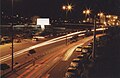 Chay Kenar highway at night

Notes
Wikiwand - on
Seamless Wikipedia browsing. On steroids.