Puerto Rico Highway 251
Highway in Puerto Rico From Wikipedia, the free encyclopedia

Puerto Rico Highway 251 (PR-251) is a road located in Culebra, Puerto Rico.[3]
Highway 251 | ||||
|---|---|---|---|---|
| Ruta 251 | ||||
| Avenida Hermanos Ávila Esperanza[1] | ||||
| Route information | ||||
| Maintained by Puerto Rico DTPW | ||||
| Length | 2.9 km[2] (1.8 mi) | |||
| Major junctions | ||||
| South end | PR-250 in Culebra barrio-pueblo | |||
| North end | Flamenco Beach in Flamenco | |||
| Location | ||||
| Country | United States | |||
| Territory | Puerto Rico | |||
| Municipalities | Culebra | |||
| Highway system | ||||
| ||||
Route description
Formerly known as PR-999,[4] this road begins in front of Benjamín Rivera Noriega Airport, at its intersection with PR-250, and runs in a northwest direction in front of the Clark and Ensenada Extension communities, reaching Flamenco Beach and Laguna Flamenco. It provides indirect access to Tamarindo Beach, Flamenco Bay and Punta Molinos in the Fraile and San Isidro neighborhoods.[5]
PR-251 was re-named Avenida Hermanos Ávila Esperanza - These six soldiers were honored for their exceptional work in the Korean and Vietnam wars and for returning home to Puerto Rico alive. Brothers (Andrés, Pedro, Norberto, Justino, Guillermo y Tomás) - The brothers also have a street named after them in Fajardo, PR (Parcelas Beltrán).[6]
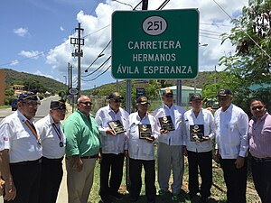 Avenida Hermanos Ávila Esperanza - Puerto Rico Highway 251

Major intersections
The entire route is located in Culebra.
| Location | km[2] | mi | Destinations | Notes | |
|---|---|---|---|---|---|
| Culebra barrio-pueblo | 0.0 | 0.0 | Southern terminus of PR-251 | ||
| Flamenco | 2.9 | 1.8 | Northern terminus of PR-251 at Flamenco Beach; dead end road | ||
| 1.000 mi = 1.609 km; 1.000 km = 0.621 mi | |||||
See also
References
External links
Wikiwand - on
Seamless Wikipedia browsing. On steroids.