Administrative divisions of Armenia
From Wikipedia, the free encyclopedia
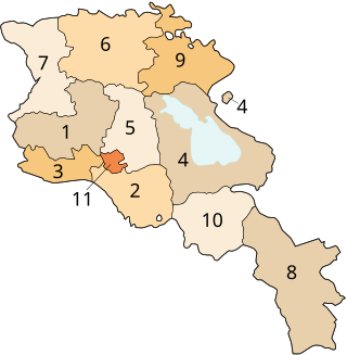
Armenia is subdivided into eleven administrative divisions. Of these, ten are provinces, known as marzer (մարզեր) or in the singular form marz (մարզ) in Armenian.
| Provinces of Armenia | |
|---|---|
 Subdivisions of Armenia
| |
| Category | Unitary state |
| Location | Armenia |
| Number | 10 Provinces 1 Special status city |
| Populations | (Provinces only): 52,324 (Vayots Dzor) – 265,770 (Armavir) |
| Areas | (Provinces only): 1,200 km2 (480 sq mi) (Armavir) – 5,350 km2 (2,065 sq mi) (Gegharkunik) |
| Government |
|
| Subdivisions | |
Yerevan is treated separately and granted special administrative status as the country's capital. The chief executive in each of 10 marzes is the marzpet, appointed by the government of Armenia. In Yerevan, the chief executive is the mayor, elected by the Yerevan City Council.
First-level administrative divisions
Summarize
Perspective
The following is a list of the provinces with population, area, and density information.[1][2] Figures are from the Statistical Committee of Armenia.[3] The area of the Gegharkunik Province includes Lake Sevan which covers 1,278 square kilometres (493 sq mi) of its territory:
| Province | Population (2011 census) |
Population (2022 census) |
% | Area (km2) | Density | Urban communities |
Rural communities |
Capital |
|---|---|---|---|---|---|---|---|---|
| Aragatsotn | 132,925 | 128,941 | 4.4% | 2,773 | 46.5/km2 (120/sq mi) | 3 | 69 | |
| Ararat | 260,367 | 248,982 | 8.5% | 2,090 | 119.1/km2 (308/sq mi) | 4 | 91 | |
| Armavir | 265,770 | 253,493 | 8.6% | 1,231 | 205.9/km2 (533/sq mi) | 3 | 94 | |
| 235,075 | 209,669 | 7.1% | 5,351 | 39.2/km2 (102/sq mi) | 5 | 52 | ||
| 254,397 | 269,883 | 9.2% | 2,076 | 130/km2 (340/sq mi) | 7 | 35 | ||
| 235,537 | 222,805 | 7.6% | 3,799 | 58.6/km2 (152/sq mi) | 7 | 50 | ||
| Shirak | 251,941 | 235,484 | 8% | 2,680 | 87.9/km2 (228/sq mi) | 3 | 39 | |
| Syunik | 141,771 | 114,488 | 3.9% | 4,506 | 25.4/km2 (66/sq mi) | 5 | 3 | |
| Tavush | 128,609 | 114,940 | 3.9% | 2,704 | 42.5/km2 (110/sq mi) | 5 | 19 | |
| 52,324 | 47,369 | 1.6% | 2,310 | 20.5/km2 (53/sq mi) | 3 | 5 | ||
| 1,060,138 | 1,086,677 | 37.1% | 223 | 4,873/km2 (12,620/sq mi) | 1 | n/a | n/a |
Municipalities (hamaynkner)
Within each province of the republic, there are municipal communities (hamaynkner, singular hamaynk), currently considered the second-level administrative division in Armenia. Each municipality - known officially as community, either rural or urban- is a self-governing entity and consists of one or more settlements (bnakavayrer, singular bnakavayr). The settlements are classified as either towns (kaghakner, singular kaghak) or villages (gyugher, singular gyugh). As of January 2018, Armenia is divided into 503 communities, of which 46 are urban and 457 are rural. The capital, Yerevan, also holds the status of a community.[4] Additionally, Yerevan is divided into twelve semi-autonomous districts.
Terminology
| Armenian singular | Armenian plural | English | Comment |
|---|---|---|---|
| marz (մարզ) | marzer (մարզեր) | province | First-level |
| hamaynk (համայնք) | hamaynkner (համայնքներ) | municipality, either urban (city/town) or rural (village) | Second-level |
| bnakavayr (բնակավայր) | bnakavayrer (բնակավայրեր) | settlement (village) | Third-level |
| t'aghayin hamaynk (թաղային համայնք) | t'aghayin hamaynkner (թաղային համայնքներ) | neighborhood community or district | only in Yerevan, see Districts of Yerevan |
See also
References
External links
Wikiwand - on
Seamless Wikipedia browsing. On steroids.
