North Lima, Ohio
Census-designated place in Ohio, United States From Wikipedia, the free encyclopedia
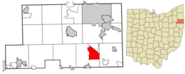
North Lima is an unincorporated community and census-designated place in eastern Beaver Township, Mahoning County, Ohio, United States. The population was 1,369 at the 2020 census.[3] Located at the intersection of State Routes 7, 164, and 165, it is part of the Youngstown–Warren metropolitan area.
North Lima, Ohio | |
|---|---|
 Mount Olivet United Church of Christ | |
 Location of North Lima in Mahoning County, Ohio. | |
| Coordinates: 40°56′59″N 80°39′40″W | |
| Country | United States |
| State | Ohio |
| County | Mahoning |
| Township | Beaver |
| Area | |
• Total | 7.07 sq mi (18.30 km2) |
| • Land | 6.86 sq mi (17.76 km2) |
| • Water | 0.21 sq mi (0.54 km2) |
| Elevation | 1,096 ft (334 m) |
| Population (2020) | |
• Total | 1,369 |
| • Density | 199.65/sq mi (77.09/km2) |
| Time zone | UTC-5 (Eastern (EST)) |
| • Summer (DST) | UTC-4 (EDT) |
| ZIP code | 44452 |
| Area code(s) | 330, 234 |
| FIPS code | 39-56798 |
| GNIS feature ID | 2812831[2] |
| School District | South Range Local School District |
History
North Lima was laid out around 1826.[4] The name may be a transfer from Lima, New York.[5] A post office called North Lima has been in operation since 1832 which bears the ZIP code of 44452.[6][7]
The former site of South Range High School is located in the town center. The building is now used to host many of the town's local businesses.[8]
Demographics
Education
Children in North Lima are served by the public South Range Local School District. The current schools serving the community are:
- South Range Elementary School – grades K-4
- South Range Middle School – grades 5-8
- South Range High School – grades 9-12
Notable people
- Charlotte Benkner, one of the oldest living persons on record, spent the last few years of her life in North Lima
- Bob Mortimer, Christian evangelist
- Samuel J. Steiner, draft resister and Mennonite historian
References
Wikiwand - on
Seamless Wikipedia browsing. On steroids.


