Top Qs
Timeline
Chat
Perspective
Kültepe
Human settlement From Wikipedia, the free encyclopedia
Remove ads
Kültepe (Turkish: lit. 'ash-hill'), also known under its ancient name Kaneš (Kanesh, sometimes also Kaniš/Kanish) or Neša (Nesha), is an archaeological site in Kayseri Province, Turkey. It was already a major settlement at the beginning of the 3rd millennium BC (Early Bronze Age), but it is world-renowned for its significance at the beginning of the 2nd millennium BC (Middle Bronze Age).[1] The archaeological site consists of a large mound (also known as höyük, tepe or tell), and a lower city, where a kārum (the Assyrian word for trading district[2]) was established in the beginning of the 2nd Millennium BC. So far, 23,500 cuneiform tablets recovered from private houses constitute the largest collection of private texts in the ancient Near East.[3] In 2014, the archaeological site was inscribed in the Tentative list of World Heritage Sites in Turkey.[3]

Remove ads
History
Summarize
Perspective
Kültepe is located about 20 km northeast from the modern city Kayseri. Its ancient name is recorded in Assyrian and Hittite sources. In Assyrian inscriptions from the 20th and the 19th century BC, the city was mentioned as Kaneš (also transcribed as Kanesh); in later Hittite inscriptions, the city was mentioned as Neša (sometimes transcribed as Nesha, Nessa or Nesa. Neša derives from [Ka]neša).
The site is divided into two main areas: the circular mound (tepe, höyük) and the lower town to its northeast. The mound was inhabited (with discontinuity) from the Early Bronze Age through the Roman Empire, while the lower town was occupied only from the last decades of the third millennium to the early sixteenth century BCE.[4] The lower town displays four levels of occupation, with only levels II (approximately 1945–1835 BCE) and Ib (approximately 1832–1700 BCE)—which roughly correspond to the Middle Bronze Age—yielding significant written records, totaling around 22,200 and 560 tablets, respectively. In contrast, only forty scattered tablets were found on the mound, where palaces and temples were uncovered, indicating that there are no surviving archives from the local authorities, if such archives ever existed.[4] This kārum appears to have served as "the administrative and distribution centre of the entire Assyrian colony network in Anatolia".[5] A late record, from circa 1400 BC, recounts the story of a king of Kaneš called Zipani, with seventeen local city-kings who rose up against Naram-Sin of Akkad, who ruled circa 2254–2218 BC.[6]
During the kārum period, and before the conquest of Pitḫana, these local kings reigned in Kaneš:
- Ḫurmili (before 1790 BC)
- Paḫanu (a short time in 1790 BC)
- Inar (c. 1790–1775 BC), then
- Waršama (c. 1775–1750 BC).[7]
The king of Zalpuwa, Uḫna, raided Kaneš, after which the Zalpuwans carried off the city's Šiuš idol. Pitḫana, the king of Kuššara, conquered Neša "in the night, by force", but "did not do evil to anyone in it".[8] Neša revolted against the rule of Pitḫana's son, Anitta, but Anitta quashed the revolt and made Neša his capital. Anitta further invaded Zalpuwa, captured its king Huzziya, and recovered the Šiuš idol for Neša.[9]
In the 17th century BC, Anitta's descendants moved their capital to Hattusa, which Anitta had cursed, thus founding the line of Hittite kings. The inhabitants thus referred to the Hittite language as Nešili 'the Neša tongue'.
Remove ads
Archaeology
Summarize
Perspective


By 1880, cuneiform tablets said to be from Kara Eyuk ('black village') or Gyul Tepé ('burnt mound') near Kaisariyeh, had begun to appear on the market, some being thus bought by the British Museum.[10] In response the site was worked by Ernest Chantre for two seasons, beginning in 1893.[11] Hugo Grothe dug a small soundage in 1906.[12] In 1925, Bedřich Hrozný excavated Kültepe and found over 1000 cuneiform tablets, some of which ended up in Prague and in Istanbul.[13][14][15] In 1929 the site was visited and photographed by James Henry Breasted of the Oriental Institute of Chicago. There had been much digging for fertilizer, which had destroyed a quarter of the mound.[16]
Modern archaeological work began in 1948, when Kültepe was excavated by a team from the Turkish Historical Society and the General Directorate of Antiquities and Museums. The team was led by Tahsin Özgüç until his death, in 2005.[17][18] After 2005 the excavation was directed by Fikri Kulakoğlu.[19][20]
- Level IV–III. Little excavation has been done for these levels, which represent the kārum's first habitation.[21] No writing is attested, and archaeologists assume that both levels' inhabitants were illiterate.
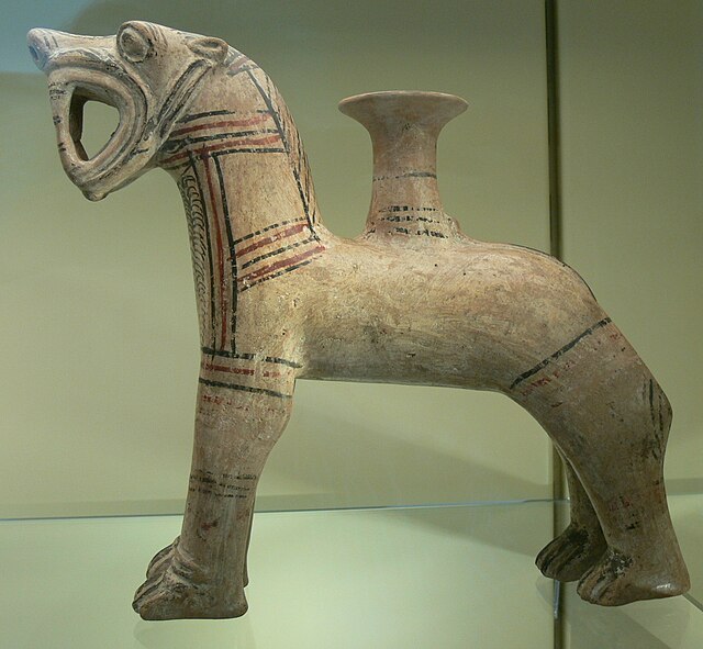
- Level II, 1974–1836 BC (Mesopotamian middle chronology according to Veenhof). Craftsmen of this time and place specialised in animal-shaped earthen drinking vessels, which were often used for religious rituals. Assyrian merchants then established the kārum of the city: "Kaneš". Bullae of Naram-Sin of Eshnunna have been found toward the end of this level, which was burned to the ground.[22]
- Level Ib, 1798–1740 BC. After an abandoned period, the city was rebuilt over the ruins of the old and again became a prosperous trade center. The trade was under the control of Ishme-Dagan I, who was put in control of Assur when his father, Shamshi-Adad I, conquered Ekallatum and Assur. However, the colony was again destroyed by fire. During excavations in 2001 140 cuneiform tablets were found in this level of the karum including a new rendition of the Kültepe eponym list.[23]
- Level Ia. The city was reinhabited, but the Assyrian colony was no longer inhabited. The culture was early Hittite. Its name in Hittite acquired an extra sound as "Kaneša", which was more commonly contracted to "Neša".
Some attribute Level II's burning to the conquest of the city of Assur by the kings of Eshnunna, but Bryce blames it on the raid of Uhna. Some attribute Level Ib's burning to the fall of Assur, other nearby kings and eventually to Hammurabi of Babylon.
To date, over 22,000 cuneiform tablets have been recovered from the site, mainly from the kārum, with only 40 found in the Upper city.[24][25][26]
Subsequent excavations attested the following stratigraphy of Kültepe:[27]
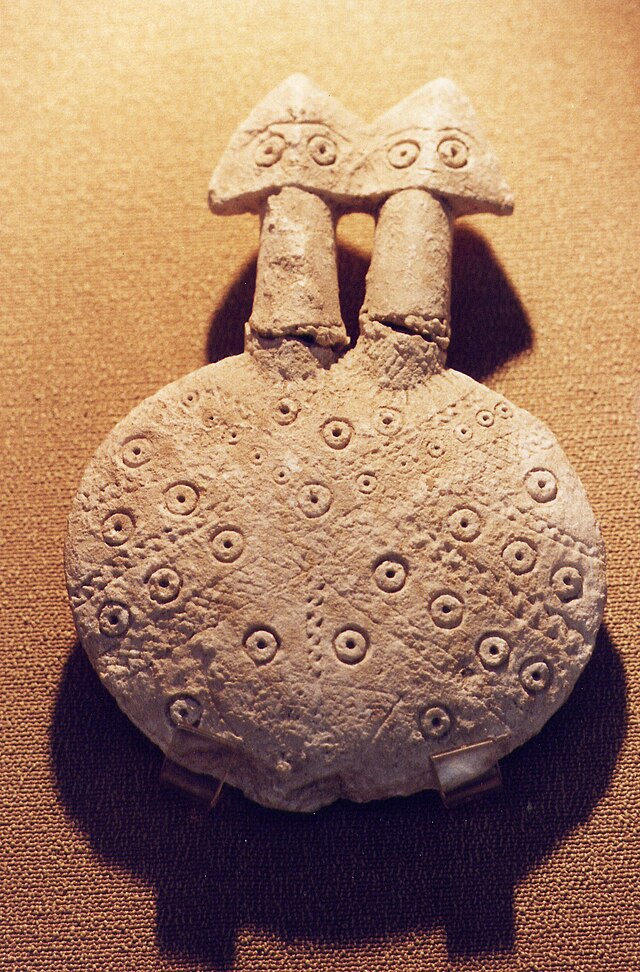
Recently, in "a small cell-plan structure cutting the walls of the monumental building [o]f Kültepe [Level 13], dated to the second half of the 3rd Millennium BC, statuettes made of alabaster with various attributes and ritual vessels in unprecedented forms were found in situ," and inside a "monumental building [d]iscovered in 2018 [which] contains a room called the 'idol room,' [a] collection of the largest number of idols and statuettes ever discovered in the ancient Near East [was found]."[31]

Kārum Kaneš
The quarter of the city that most interests historians is the kārum, a portion of the city that was set aside by local officials for the early Assyrian merchants to use without paying taxes as long as the goods remained inside the kārum. The term kārum means "port" in Akkadian, the lingua franca of the time, but its meaning was later extended to refer to any trading colony whether or not it bordered water.
Several other cities in Anatolia also had a kārum, but the largest was Kaneš, whose important kārum was inhabited by soldiers and merchants from Assyria for hundreds of years. They traded local tin and wool for luxury items, foodstuffs, spices and woven fabrics from the Assyrian homeland and Elam.
The remains of the kārum form a large circular mound 500 m in diameter and about 20 m above the plain (a tell). The kārum settlement is the result of several superimposed stratigraphic periods. New buildings were constructed on top of the remains of the earlier periods so there is a deep stratigraphy from prehistoric times to the early Hittite period.
The kārum was destroyed by fire at the end of levels II and Ib. The inhabitants left most of their possessions behind, as found by modern archaeologists.
The findings have included numerous baked-clay tablets, some of which were enclosed in clay envelopes stamped with cylinder seals.[32] The documents record common activities, such as trade between the Assyrian colony and the city-state of Assur and between Assyrian merchants and local people. The trade was run by families rather than the state. The Kültepe texts are the oldest documents from Anatolia. Although they are written in Old Assyrian, the Hittite loanwords and names in the texts are the oldest record of any Indo-European language.[33] Most of the archaeological evidence is typical of Anatolia rather than of Assyria, but the use of both cuneiform and the dialect is the best indication of Assyrian presence.
Dating of Waršama Sarayi
At Level II, the destruction was so total that no wood survived for dendrochronological studies. In 2003, researchers from Cornell University dated wood in level Ib from the rest of the city, built centuries earlier. The dendrochronologists date the bulk of the wood from buildings of the Waršama Sarayi to 1832 BC, with further refurbishments up to 1779 BC.[34] In 2016 new research using radiocarbon dating and dendrology on timber used in this site and the palace in Acemhöyük show the likely earliest use of the palace as not before 1851–1842 BC (68.2% hpd) or 1855–1839 BC (95.4% hpd).[35] In combination with the many Assyrian objects found here, this dating shows that only middle or low-middle chronology are the only remaining possible chronologies that fit these new data.
Remove ads
See also
References
Sources
External links
Wikiwand - on
Seamless Wikipedia browsing. On steroids.
Remove ads


