Molėtai District Municipality
Municipality in Aukštaitija, Lithuania From Wikipedia, the free encyclopedia
The Molėtai District Municipality is one of 60 municipalities in Lithuania.
Molėtai District Municipality
Molėtų rajono savivaldybė | |
|---|---|
 Svobiškėlis mound | |
 Flag .svg) Coat of arms | |
 Location of Molėtai district municipality within Lithuania | |
 Map of Molėtai district municipality | |
| Country | Lithuania |
| Ethnographic region | Aukštaitija |
| County | |
| Capital | Molėtai |
| Elderships | 11 |
| Area | |
• Total | 1,368 km2 (528 sq mi) |
| • Rank | 22nd |
| Population (2021[1]) | |
• Total | 17,222 |
| • Rank | 48th |
| • Density | 13/km2 (33/sq mi) |
| • Rank | 56th |
| Time zone | UTC+2 (EET) |
| • Summer (DST) | UTC+3 (EEST) |
| Telephone code | 383 |
| Major settlements | Molėtai (pop. 5,716) |
| Website | www |
Molėtai is known for its many lakes. There are about 220 lakes in the district and they cover about 7% of the total territory. Since it is only about 60 km north of Vilnius, many Vilnians own summer homes there. The area offers many recreational opportunities. It is easy to reach Molėtai because there is a highway connecting Vilnius and Utena which divides the district into two almost equal parts. Since there is little industry, the district is proud of its lack of pollution. The land is not very fertile[citation needed], therefore the district's government is focused on developing tourism.
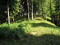
Another natural resource of the district are its forests which cover about 26.6% of its territory.
Structure
District structure:
Population of largest Molėtai District Municipality elderships (2011):
- Molėtai – 6434
- Giedraičiai – 684
- Naujasodis – 496
- Suginčiai – 426
- Toliejai – 379
- Videniškiai – 368
- Alanta – 348
- Balninkai – 319
- Joniškis – 258
- Inturkė – 237
Nature and geography
 Landscape near Alanta
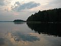
 Kertuojis mound
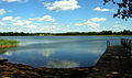 Kiementas lake


References
Wikiwand - on
Seamless Wikipedia browsing. On steroids.