Makinohara
City in Chūbu, Japan From Wikipedia, the free encyclopedia
City in Chūbu, Japan From Wikipedia, the free encyclopedia
Makinohara (牧之原市, Makinohara-shi) is a city located in western Shizuoka Prefecture, Japan. As of 31 July 2019[update], the city had an estimated population of 45,813 in 16980 households [1] and a population density of 410 persons per km². The total area of the city was 111.69 square kilometres (43.12 sq mi).
Makinohara
牧之原市 | |
|---|---|
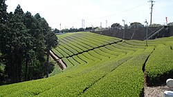
 Tea plantations in Makinohara | |
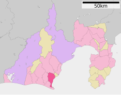
 Location of Makinohara in Shizuoka Prefecture | |
| Coordinates: 34°44′N 138°13′E | |
| Country | Japan |
| Region | Chūbu (Tōkai) |
| Prefecture | Shizuoka |
| First official recorded | 6 BC |
| Sagara Town settled | April 1, 1889 |
| Haibara Town settled | April 1, 1955 |
| Both town merged and city settled | October 11, 2005 |
| Government | |
| • Mayor | Kikuo Sugimoto (from October 2017) |
| Area | |
| • Total | 111.69 km2 (43.12 sq mi) |
| Population (July 31, 2019) | |
| • Total | 45,813 |
| • Density | 410/km2 (1,100/sq mi) |
| Time zone | UTC+9 (Japan Standard Time) |
| Phone number | 548-23-0001 |
| Address | 447 Shizunami, Makinohara-shi, Shizuoka-ken 421-0495 |
| Climate | Cfa |
| Website | Official website |
| Symbols | |
| Flower | hydrangea |
| Tree | camellia sinensis |

Makinohara is located in south-central Shizuoka Prefecture. It is bordered by Suruga Bay on the Pacific Ocean to the east, and rises gradually to the Makinohara Plateau in the west. The area has a temperate maritime climate, characterized by hot, humid summers and mild winters, with the warm Kuroshio Current off shore providing a moderating effect.
Shizuoka Prefecture
Per Japanese census data,[2] the population of Makinohara has been relatively steady over the past 50 years.
| Year | Pop. | ±% |
|---|---|---|
| 1940 | 44,565 | — |
| 1950 | 55,066 | +23.6% |
| 1960 | 50,993 | −7.4% |
| 1970 | 47,953 | −6.0% |
| 1980 | 48,835 | +1.8% |
| 1990 | 51,308 | +5.1% |
| 2000 | 51,672 | +0.7% |
| 2010 | 49,022 | −5.1% |
The city has a climate characterized by hot and humid summers, and relatively mild winters (Köppen climate classification Cfa). The average annual temperature in Makinohara is 16.0 °C (60.8 °F). The average annual rainfall is 2,269.4 mm (89.35 in) with July as the wettest month. The temperatures are highest on average in August, at around 26.6 °C (79.9 °F), and lowest in January, at around 5.6 °C (42.1 °F).[3]
| Climate data for Shizuoka Airport, Makinohara (2009−2020 normals, extremes 2009−present) | |||||||||||||
|---|---|---|---|---|---|---|---|---|---|---|---|---|---|
| Month | Jan | Feb | Mar | Apr | May | Jun | Jul | Aug | Sep | Oct | Nov | Dec | Year |
| Record high °C (°F) | 18.8 (65.8) |
20.6 (69.1) |
25.4 (77.7) |
25.6 (78.1) |
30.6 (87.1) |
33.9 (93.0) |
35.9 (96.6) |
36.8 (98.2) |
36.2 (97.2) |
31.5 (88.7) |
24.7 (76.5) |
22.0 (71.6) |
36.8 (98.2) |
| Mean daily maximum °C (°F) | 10.5 (50.9) |
11.5 (52.7) |
14.8 (58.6) |
18.6 (65.5) |
23.1 (73.6) |
25.4 (77.7) |
29.0 (84.2) |
30.8 (87.4) |
27.3 (81.1) |
22.6 (72.7) |
17.8 (64.0) |
12.6 (54.7) |
20.3 (68.6) |
| Daily mean °C (°F) | 5.6 (42.1) |
6.7 (44.1) |
9.9 (49.8) |
13.9 (57.0) |
18.5 (65.3) |
21.5 (70.7) |
25.2 (77.4) |
26.6 (79.9) |
23.4 (74.1) |
18.6 (65.5) |
13.4 (56.1) |
8.1 (46.6) |
16.0 (60.7) |
| Mean daily minimum °C (°F) | 1.7 (35.1) |
2.6 (36.7) |
5.5 (41.9) |
9.7 (49.5) |
14.5 (58.1) |
18.4 (65.1) |
22.4 (72.3) |
23.7 (74.7) |
20.3 (68.5) |
15.4 (59.7) |
9.8 (49.6) |
4.3 (39.7) |
12.4 (54.2) |
| Record low °C (°F) | −4.5 (23.9) |
−5.0 (23.0) |
−1.8 (28.8) |
1.1 (34.0) |
6.2 (43.2) |
11.6 (52.9) |
17.4 (63.3) |
18.2 (64.8) |
14.5 (58.1) |
8.1 (46.6) |
1.3 (34.3) |
−3.0 (26.6) |
−5.0 (23.0) |
| Average precipitation mm (inches) | 56.4 (2.22) |
126.6 (4.98) |
181.5 (7.15) |
240.3 (9.46) |
210.5 (8.29) |
262.8 (10.35) |
292.0 (11.50) |
156.3 (6.15) |
261.0 (10.28) |
264.6 (10.42) |
121.1 (4.77) |
83.3 (3.28) |
2,269.4 (89.35) |
| Average precipitation days (≥ 1.0 mm) | 4.1 | 6.7 | 9.4 | 10.1 | 8.7 | 12.3 | 12.3 | 9.3 | 11.4 | 9.6 | 7.1 | 5.9 | 106.9 |
| Source: Japan Meteorological Agency[4][3] | |||||||||||||
The area of present-day Makinohara was part of former Tōtōmi Province. During the Edo period, the town of Sagara was the castle town of Sagara Domain. With the establishment of the modern municipalities system in the early Meiji period on April 1, 1889, Sagara was incorporated as a town within Haibara District.
The city of Makinohara was established on October 11, 2005, from the merger of the towns of Haibara and Sagara (both from Haibara District).
Makinohara has a mayor-council form of government with a directly elected mayor and a unicameral city legislature of 16 members. The city contributes one member to the Shizuoka Prefectural Assembly.
The local economy of Makinohara is dominated by the production of green tea, and to a lesser extent by commercial fishing, and manufacturing of automobile components for Suzuki Motors (Sagara Plant).[5]
Fuji Dream Airlines has its headquarters in Makinohara.[6]
Makinohara has seven public elementary schools operated by the city government and one shared between Makinohara and Kikugawa, and three shared between Makinohara and Omaezaki. The city likewise operates two public junior high schools and shares operated with one junior high school with Kikugawa and one with Omaezaki. The city has two public high schools operated by the Shizuoka Prefectural Board of Education.
Although both the Tokaido Shinkansen and the Tokaido Main Line pass through Makinohara, the city has no passenger railway services. The nearest train station is Kikugawa Station in neighboring Kikugawa or Kanaya Station in neighboring Shimada.
Shizuoka Airport, which opened in 2009, straddles the border between Makinohara and Shimada.
Seamless Wikipedia browsing. On steroids.
Every time you click a link to Wikipedia, Wiktionary or Wikiquote in your browser's search results, it will show the modern Wikiwand interface.
Wikiwand extension is a five stars, simple, with minimum permission required to keep your browsing private, safe and transparent.