Los Salias Municipality
Municipality in Miranda, Venezuela From Wikipedia, the free encyclopedia
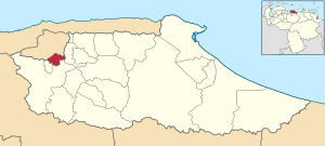
Los Salias, founded in 1982, is one of the 21 municipalities (municipios) that makes up the Venezuelan state of Miranda and, according to a 2011 population estimate by the National Institute of Statistics of Venezuela, the municipality has a population of 68000.[1] It's located approximately 14 km away from Caracas and it borders with the Capital District to the north, Guaicaipuro Municipality to the south, Baruta to the east and Carrizal to the west. Los Salias has an Area of 51 km2 and a max altitude of 1700 metres above sea level. The town of San Antonio de Los Altos is the municipal seat of Los Salias.[2]
Los Salias Municipality
Municipio Los Salias | |
|---|---|
| Nickname: Ciudad Dormitorio | |
 Location in Miranda | |
| Coordinates: 10°22′58″N 66°56′56″W | |
| Country | Venezuela |
| State | Miranda |
| Founded | May 1st 1683 |
| Municipal seat | San Antonio de Los Altos |
| Government | |
| • Mayor | José Antonio Fernández López (Un Nuevo Tiempo) |
| Area | |
• Total | 63.3 km2 (24.4 sq mi) |
| Population (2011) | |
• Total | 68,000 |
| • Density | 1,100/km2 (2,800/sq mi) |
| Time zone | UTC−4 (VET) |
| Postal code(s) | 1204 |
| Area code(s) | 0212 |
| Website | Official website |
Demographics
According to a 2011 population estimate by the National Institute of Statistics of Venezuela (INE), Los Salias Municipality, has a population of 68.000. The municipality's population density is 1,333.33 inhabitants per square kilometre (3,453.3/sq mi).[3]
Government
The mayor of the Los Salias Municipality is José Antonio Fernández López, elected on December 12 with 59.9% of the vote.[4] The municipality is divided into one parish (San Antonio de Los Altos).[2]
References
Wikiwand - on
Seamless Wikipedia browsing. On steroids.


