List of regions of China
From Wikipedia, the free encyclopedia
This is a list of traditional top-level regions of China.
An editor has performed a search and found that sufficient sources exist to establish the subject's notability. (October 2023) |
People's Republic of China
Summarize
Perspective
Statistical regions
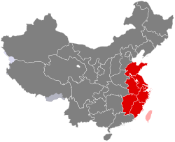
This is a list of the 34 provincial-level divisions of the People's Republic of China grouped by its former greater administrative areas from 1949 to 1952.
 |
North China |
East China |
Southwestern China |
Northwestern China |
South Central China |
Northeast China |
Other kinds of statistics

| Region | Area | Population (2010) | Population Density | Provinces included & Notes |
|---|---|---|---|---|
| North China (without Eastern Inner Mongolia) |
1,082,492 km2 | 153,180,300 | 142/km2 | Beijing, Tianjin, Hebei, Shanxi, and Inner Mongolia (without Chifeng, Hinggan, Hulunbuir, and Tongliao) |
| Northeast China (with Eastern Inner Mongolia) |
1,266,869 km2 | 121,163,770 | 96/km2 | Liaoning, Jilin, Heilongjiang, and Eastern Inner Mongolia (Chifeng, Hinggan, Hulunbuir, and Tongliao) |
| East China | 832,028 km2 | 407,527,091 | 499/km2 | The above-mentioned seven entities plus the claimed Taiwan Province. Taiwan and its surrounding island groups are administered by the Republic of China but claimed by the People's Republic of China. |
| Central China | 564,700 km2 | 216,945,029 | 384/km2 | Henan, Hubei, and Hunan |
| South China | 449,654 km2 | 166,614,779 | 371/km2 | Guangdong, Guangxi, Hainan, Hong Kong, and Macau |
| Western China | 3,978,700 km2 | 289,623,281 | 73/km2 | Chongqing, Sichuan, Guizhou, Yunnan, Tibet, Shaanxi, Gansu, Qinghai, Ningxia, and Xinjiang |
Economic regions
 |
East Coast |
Western China |
Central China |
Northeast China |
PLA military regions

See also
Wikiwand - on
Seamless Wikipedia browsing. On steroids.


