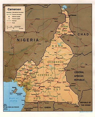
This is the list of cities , towns, and villages in the country of Cameroon :
Yaoundé , Capital and 2nd largest city of Cameroon Bamenda Bafoussam Bangangté Bafut Palace Garoua Maroua Babanki Tunguh The Lake Bambili Kaélé, Boboyo Crocodile Lake Yagoua Wum culture Yokadouma Douala, King Bell's Palace More information City, Region ...
Municipalities in Cameroon[ 1] [ 2]
City
Region
Population (2021), References
Abong-Mbang East 14,661[ 1]
Ako Northwest 40,349
Akonolinga Centre 17,181[ 1]
Ambam South 8,476[ 1]
Bafang West 80,688[ 1]
Bafia Centre 69,270[ 1]
Bafoussam (Regional capital)West 290,768[ 1]
Bafut (Kingdom)Northwest 120,000[ 3]
Bali Northwest 72,606[ 1]
Bambili (French)Northwest 5,641[ 4]
Bamenda (Regional capital)Northwest 393,835[ 1]
Batibo Northwest 9,163[ 1]
Bandjoun West 6,872[ 1]
Bangem Southwest
Banyo Adamawa 40,798[ 1]
Batouri East 43,821[ 1]
Bélabo East 22,553[ 1]
Bertoua (Regional capital)East 218,111[ 1]
Buea (Regional capital)Southwest 47,300[ 1]
Campo South
Dimako East 8,476[ 1]
Dizangue Littoral 19,243[ 1]
Djoum South 18,050
Douala (Regional capital, port, railhead )Littoral 1,338,082[ 1]
Dschang West 96,112[ 1]
Ebolowa (Regional Capital)South 87,875[ 1]
Edéa Littoral 203,149[ 1]
Eyumojock Southwest
Fontem Southwest 42,689[ 1]
Foumban West 92,673[ 1]
Foumbot West 84,065[ 1]
Fundong Northwest 43,509[ 1]
Garoua (Regional capital)North 436,899[ 1]
Garoua-Boulaï East 46,615[ 1]
Guider North 84,647[ 1]
Idenau Southwest
Kaélé Far North 25,199[ 1]
Kousséri Far North 435,547[ 1]
Kribi South 55,224[ 1]
Kumba Southwest 144,413[ 1]
Kumbo Northwest 53,970[ 1]
Limbé Southwest 72,106[ 1]
Lomié East
Loum Littoral 177,429[ 1]
Makénéné Centre
Mamfe Southwest 19,472[ 1]
Manjo Littoral 37,661[ 1]
Maroua (Regional capital)Far North 319,941[ 1]
Martap Adamawa
Mbalmayo Centre 80,206[ 1]
Mbandjock (Mbandjok)Centre 26,947[ 1]
Mbanga Southwest 42,590[ 1]
Mbê Multiple [ 2]
Mbengwi Northwest 9,734[ 1]
Mbouda West 111,320[ 1]
Meiganga Adamawa 80,100[ 1]
Melong Littoral 37,086[ 1]
Menji Southwest
Muyuka Southwest 31,384[ 1]
Nkoteng Centre 50,334[ 1]
Mokolo Far North 275,239[ 1]
Monatélé Centre
Mora Far North 55,216[ 1]
Mouloudou East
Mutengene Southwest 47,478[ 1]
Nanga Eboko Centre 29,909[ 1]
Ndu Northwest
Ndop Northwest 25,740[ 1]
Ngaoundéré (Regional capital, railhead)Adamawa 231,357[ 1]
Nkambe Northwest 17,191[ 1]
Nkongsamba Littoral 117,063[ 1]
Nkwen Northwest and West
Obala Centre 30,012[ 1]
Penja Littoral 28,406[ 1]
Sa'a Centre 5,727[ 1]
Sangmélima South 54,251[ 1]
Santa Northwest
Tibati Adamawa 35,589[ 1]
Tiko Southwest 55,914[ 1]
Wum Northwest 68,836[ 1]
Yaoundé (capital)Centre 1,299,369[ 1]
Yagoua Far North 80,235[ 1]
Yokadouma East 13,287[ 1]
Ndop Northwest
Close
Major cities of Cameroon 


