| Historic site |
Image |
Location |
Nearest city |
County |
Coordinates |
Supervising agency |
Notes |
| Acton State Historic Site |
 |
FM 167 |
Acton |
Hood |
32°26′25″N 97°41′5″W |
THC |
|
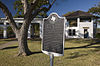
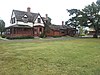
| Barrington Plantation |
 |
Park Road 12 |
Washington-on-the-Brazos |
Washington |
30°19′21″N 96°9′0″W |
THC |
|
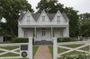
| Bush Family Home State Historic Site#⁑ |
|
1412 W. Ohio St. |
Midland |
Midland |
32°0′2″N 102°5′24″W |
THC |
|
| Caddo Mounds State Historic Site† |

 More images More images |
1649 W. SH 21 |
Alto |
Cherokee |
31°35′47″N 95°8′55″W |
THC |
|
| Casa Navarro State Historic Site#†⁕⁑ |
 |
228 S. Laredo St. |
San Antonio |
Bexar |
29°25′23″N 98°29′51″W |
THC |
|
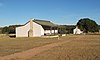
| Confederate Reunion Grounds State Historic Site† |

More images |
1738 FM 2705 |
Mexia |
Limestone |
31°38′1″N 96°33′26″W |
THC |
|
| Eisenhower Birthplace State Historic Site†⁑ |
More images |
609 S. Lamar Ave. |
Denison |
Grayson |
33°44′59″N 96°32′3″W |
THC |
|
| Fannin Battleground State Historic Site‡ |
 |
734 FM 2506 |
Fannin |
Goliad |
28°41′11″N 97°14′2″W |
THC |
|
| Fanthorp Inn State Historic Site⁂⁕ |

More images |
579 S. Main St. |
Anderson |
Grimes |
30°28′59″N 95°59′2″W |
THC |
Part of Anderson Historic District |
| Fort Griffin State Historic Site†⁕ |

More images |
1701 N. US 283 |
Albany |
Jones |
32°55′11″N 99°13′45″W |
THC |
|
| Fort Lancaster and Battlefield State Historic Site†⁕ |

More images |
629 Ft. Lancaster Rd. |
Sheffield |
Pecos |
30°39′34″N 101°41′36″W |
THC |
|
| Fort Leaton State Historic Site†⁕ |

More images |
FM 170 E. |
Presidio |
Presidio |
29°32′33″N 104°19′37″W |
TPWD |
|
| Fort Martin Scott State Historic Site |
 |
1606 E. Main St. |
Fredericksburg |
Gillespie |
30°14′58″N 98°50′47″W |
THC |
|
| Fort McKavett State Historic Site‡ |

More images |
7066 FM 864 |
Fort McKavett |
Menard |
30°49′28″N 100°6′38″W |
THC |
|
| Fort Richardson State Park and Historic Site#†⁕⁑ |

More images |
228 Park Road 61 |
Jacksboro |
Jack |
33°12′22″N 98°9′25″W |
TPWD |
|
| French Legation State Historic Site†⁕⁑ |
 |
802 San Marcos St. |
Austin |
Travis |
30°16′01″N 97°43′56″W |
THC |
|
| Fulton Mansion State Historic Site†⁕⁑ |
More images |
317 S. Fulton Beach Rd. |
Rockport |
Aransas |
28°3′25″N 97°2′7″W |
THC |
|
| Goliad State Park and Historic Site‡⁕⁑ |

More images |
108 Park Road 6 |
Goliad |
Goliad |
28°39′23″N 97°23′7″W |
TPWD |
|
| Goodnight Ranch State Historic Site† |
 |
4989 CR 25 |
Goodnight |
Armstrong |
35°1′50″N 101°10′59″W |
THC |
|
| Hueco Tanks State Park and Historic Site† |

More images |
6900 Hueco Tanks Road No. 1 |
El Paso |
El Paso |
31°55′2″N 106°2′38″W |
TPWD |
|
| Iwo Jima Museum and Monument State Historic Site |
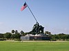 |
320 Iwo Jima Blvd. |
Harlingen |
Cameron |
26°13′31″N 97°39′59″W |
THC |
|
| Landmark Inn State Historic Site†⁕⁑ |

More images |
402 E. Florence St. |
Castroville |
Medina |
29°21′18″N 98°52′29″W |
THC |
|
| Levi Jordan Plantation State Historic Site⁑ |
 |
7234 FM 521 |
Brazoria |
Brazoria |
28°59′57″N 95°38′54″W |
THC |
|
| Lipantitlan State Historic Site |
Upload image |
Lipantitlan Park Rd. |
Orange Grove |
Nueces |
27°57′53″N 97°49′4″W |
THC |
|
| Lyndon B. Johnson State Park and Historic Site‡ |

More images |
Park Road 52 |
Stonewall |
Gillespie |
30°14′16″N 98°37′35″W |
TPWD |
|
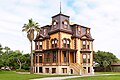
| Magoffin Home State Historic Site†⁂⁕⁑ |
More images |
1120 Magoffin Ave. |
El Paso |
El Paso |
31°45′46″N 106°28′39″W |
THC |
Part of Magoffin Historic District |
| Mission Dolores State Historic Site† |
 |
701 S. Broadway St. |
San Augustine |
San Augustine |
31°31′27″N 94°6′49″W |
THC |
|
| Monument Hill and Kreische Brewery State Historic Sites†⁕ |

More images |
414 Loop 92 |
La Grange |
Fayette |
29°53′20″N 96°52′31″W |
THC |
|
| National Museum of the Pacific War⁕ |

More images |
340 E. Main St. |
Fredericksburg |
Gillespie |
30°16′19″N 98°52′2″W |
THC |
|
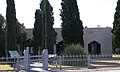
| Old Socorro Mission State Historic Site |
|
10551 Nicholas Rd. |
Socorro |
El Paso |
|
THC |
|
| Palmito Ranch Battlefield State Historic Site#† |
|
43296 Palmito Hill Rd. |
Brownsville |
Cameron |
25°56′48″N 97°17′7″W |
THC |
|
| Port Isabel Lighthouse State Historic Site† |
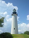
More images |
421 E. Queen Isabella Blvd. |
Port Isabel |
Cameron |
26°4′41″N 97°12′26″W |
THC |
|
| Presidio La Bahía State Historic Site#†⁑ |
 |
217 Loop 71 |
Goliad |
Goliad |
28°38′48″N 97°22′54″W |
THC |
|
| Sabine Pass Battleground State Historic Site |
 |
6100 Dowling Rd. |
Port Arthur |
Jefferson |
29°43′43″N 93°52′30″W |
THC |
|
| Sam Bell Maxey House State Historic Site†⁕⁑ |

More images |
812 S. Church St. |
Paris |
Lamar |
33°39′14″N 95°33′17″W |
THC |
|
| Sam Rayburn House State Historic Site#†⁑ |
 |
890 W. SH 56 |
Bonham |
Fannin |
33°34′10″N 96°12′27″W |
THC |
|
| San Felipe de Austin State Historic Site‡ |

More images |
15945 FM 1458 |
San Felipe |
Austin |
29°48′25″N 96°5′51″W |
THC |
|
| San Jacinto Battleground State Historic Site#†⁕ |

More images |
3523 Independence Pkwy S. |
LaPorte |
Harris |
29°44′18″N 95°4′41″W |
THC |
|
| Seminole Canyon State Park and Historic Site‡ |
More images |
US 90 |
Comstock |
Val Verde |
29°42′0″N 101°18′47″W |
TPWD |
|
| Starr Family Home State Historic Site†⁕ |

More images |
407 W. Travis St. |
Marshall |
Harrison |
32°32′30″N 94°22′15″W |
THC |
|
| Stephen F. Austin Memorial State Historic Site |
|
900 Oil Field Rd. |
West Columbia |
Brazoria |
29°9′21″N 95°39′13″W |
THC |
|
| Varner–Hogg Plantation State Historic Site†⁕⁑ |

More images |
1702 N. 13th St. |
West Columbia |
Brazoria |
29°9′45″N 95°38′28″W |
THC |
|
| Washington-on-the-Brazos State Historic Site |

More images |
23400 Park Road 12 |
Washington |
Washington |
30°19′25″N 96°9′17″W |
THC |
|


.jpg)


.jpg)


.jpg)
.jpg)
