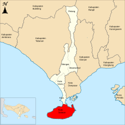
South Kuta (Indonesian: Kuta Selatan) is a district (kecamatan) within Badung Regency of Bali. It consists of Nusa Dua, a large peninsula projecting south from Bali island.
South Kuta Kuta Selatan | |
|---|---|
 Location of South Kuta District within Badung Regency | |
| Country | Indonesia |
| Region | Lesser Sunda Islands |
| Province | Bali |
| Regency | Badung |
| Area | |
| • Total | 101.13 km2 (39.05 sq mi) |
| Population (2020) | |
| • Total | 131,139 |
| • Density | 1,300/km2 (3,400/sq mi) |
| Website | kutaselatan |
It covers 101.13 km2 and had a population of 116,143 people as of the 2010 Census [1] and 131,139 at the 2020 Census.[2]
It includes six villages, listed below with their areas and their populations at the 2010 Census[3] and 2020 Census.[4]
| Name | Area in km2 | Pop'n 2010 Census | Pop'n 2020 Census |
|---|---|---|---|
| Pecatu | 26.41 | 7,378 | 13,713 |
| Ungasan | 14.99 | 14,221 | 16,716 |
| Kutuh | 8.56 | 3,606 | 5,322 |
| Benoa | 28.28 | 39,570 | 41,722 |
| Tanjung Benoa | 2.39 | 6,767 | 6,376 |
| Jimbaran | 20.50 | 44,376 | 47,290 |
| Totals | 101.13 | 115,918 | 131,139 |
Jimbaran lies at the southern end of the isthmus connecting the Nusa Dua (or Bukit Badung) peninsula - a harsh, scrubby limestone plateau off the south side of Bali - with Kuta and Tuban further north. Pecatu, Ungasan and Kutuh are villages high up on the plateau, while Benoa lies at the eastern end of the peninsula and contains the resort area of Nusa Dua, with Tanjung Benoa forming a narrow sandbar extending north towards Denpasar.
References
External links
Wikiwand in your browser!
Seamless Wikipedia browsing. On steroids.
Every time you click a link to Wikipedia, Wiktionary or Wikiquote in your browser's search results, it will show the modern Wikiwand interface.
Wikiwand extension is a five stars, simple, with minimum permission required to keep your browsing private, safe and transparent.
