Kestilä
Place in Northern Ostrobothnia, Finland From Wikipedia, the free encyclopedia
Place in Northern Ostrobothnia, Finland From Wikipedia, the free encyclopedia
Kestilä is a village and former municipality of Finland. It is located in the province of Oulu and is part of the Northern Ostrobothnia region.
Kestilä | |
|---|---|
Village, former municipality | |
| Kestilän kunta Kestilä kommun | |
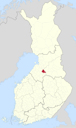
 Location of Kestilä in Finland | |
| Coordinates: 64°21′N 026°17′E | |
| Country | Finland |
| Region | Northern Ostrobothnia |
| Sub-region | Siikalatva sub-region |
| Charter | 1867 |
| Consolidated | 2009 |
| Area | |
• Total | 606.53 km2 (234.18 sq mi) |
| • Land | 601.44 km2 (232.22 sq mi) |
| • Water | 5.09 km2 (1.97 sq mi) |
| Population (2015-12-31)[2] | |
• Total | 536 |
| • Density | 0.88/km2 (2.3/sq mi) |
| Time zone | UTC+2 (EET) |
| • Summer (DST) | UTC+3 (EEST) |
Established in 1867, the population was 536 as of 31 December 2015.[2] The municipality covered an area of 606.53 km2 (234.18 sq mi) of which 5.09 km2 (1.97 sq mi) is water.[1]
The municipality was unilingually Finnish.
The municipality was consolidated with Piippola, Pulkkila and Rantsila on 2009-01-01 to form a new municipality of Siikalatva.[3]
Seamless Wikipedia browsing. On steroids.
Every time you click a link to Wikipedia, Wiktionary or Wikiquote in your browser's search results, it will show the modern Wikiwand interface.
Wikiwand extension is a five stars, simple, with minimum permission required to keep your browsing private, safe and transparent.