Kendua Upazila
Upazila in Mymensingh, Bangladesh From Wikipedia, the free encyclopedia
Kendua (Bengali: কেন্দুয়া) is an upazila of Netrokona District[4] in the Division of Mymensingh, Bangladesh.
Kendua
কেন্দুয়া | |
|---|---|
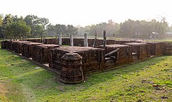
 Baraduari Mound, Royalbari | |
 | |
| Coordinates: 24°39′N 90°50.5′E | |
| Country | Bangladesh |
| Division | Mymensingh |
| District | Netrokona |
| Area | |
• Total | 303.6 km2 (117.2 sq mi) |
| Population | |
• Total | 316,976 |
| • Density | 1,000/km2 (2,700/sq mi) |
| Time zone | UTC+6 (BST) |
| Postal code | 2480[2] |
| Area code | 09528[3] |
| Website | kendua |
Geography
Kendua is located at 24.6500°N 90.8417°E. It has 66133 households and total area 303.60 km2 (117.22 sq mi). The upazila is bounded by Netrokona Sadar and Atpara upazilas on the north, Tarail Upazila of Kishoreganj district on the south, Madan upazila on the east, Ishwarganj, Gauripur and Nandail upazilas on the west.

Demographics
According to the 2011 Census of Bangladesh, Kendua Upazila had 66,133 households and a population of 304,729. 87,575 (28.74%) were under 10 years of age. Kendua has a literacy rate (age 7 and over) of 37.58%, compared to the national average of 51.8%, and a sex ratio of 1031 females per 1000 males. 22,363 (7.34%) lived in urban areas.[6][7]
As of the 1991 Bangladesh census, Kendua had a population of 265628. Males constituted 50.58% of the population, and females 49.42%. This Upazila's eighteen up population was 133969. Kendua had an average literacy rate of 37.1% (7+ years), and the national average of 32.4% literate.[8]
Administration
Kendua Thana was formed 1890 and it was turned into an upazila in 1983.[4]
Kendua Upazila is divided into Kendua Municipality and 13 union parishads: Asujia, Balaishimul, Chirang, Dalpa, Garadoba, Ganda, Kandiura, Mashka, Muzaffarpur, Noapara, Paikura, Roailbari, and Sandikona. The union parishads are subdivided into 217 mauzas and 289 villages.[9]
Kendua Municipality is subdivided into 9 wards and 32 mahallas.[9]
Notable people
- Nalini Ranjan Sarkar
- Kuddus Boyati
- Raushan Yazdani, author and folklorist
- Mohammad Ainal Haque, poet and journalist
- Chandra Kumar De, folklorist and writer
- Humayun Ahmed, Famous Bengali Novelist and film director
- Jalal Uddin Khan, author and folk lyricist[10]
See also
References
Wikiwand - on
Seamless Wikipedia browsing. On steroids.
