Top Qs
Timeline
Chat
Perspective
Armour, Ontario
Township municipality in Ontario, Canada From Wikipedia, the free encyclopedia
Remove ads
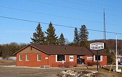
Armour (2021 population 1,459) is a township municipality in the Canadian province of Ontario.[2][5][6]
Remove ads
Located in the Almaguin Highlands region of Parry Sound District, the township surrounds but does not include the village of Burk's Falls. It was named in honour of Judge John Douglas Armour.[1]
Remove ads
Communities
The township includes the communities of Berriedale, Carss, Chetwynd, Katrine and Pickerel Lake.
Katrine overlooks Doe Lake, which is located on the west side of the village. Three Mile Lake and Deer Lake are located about 5 km east of the village. There is also a small public beach on Doe Lake, and a community centre located on Ontario Highway 11.[7]
Demographics
In the 2021 Census of Population conducted by Statistics Canada, Armour had a population of 1,459 living in 667 of its 1,087 total private dwellings, a change of 3.2% from its 2016 population of 1,414. With a land area of 163.52 km2 (63.14 sq mi), it had a population density of 8.9/km2 (23.1/sq mi) in 2021.[10]
Mother tongue (2006):[11]
- English as first language: 92.4%
- French as first language: 2.4%
- English and French as first language: 0%
- Other as first language: 5.2%
Remove ads
See also
References
External links
Wikiwand - on
Seamless Wikipedia browsing. On steroids.
Remove ads


