Kanije Eyalet
Administrative division of the Ottoman Empire from 1600 to 1690 From Wikipedia, the free encyclopedia
Administrative division of the Ottoman Empire from 1600 to 1690 From Wikipedia, the free encyclopedia
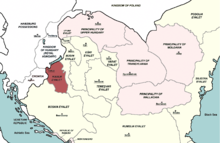
The Kanije Eyalet (Ottoman Turkish: ایالت قنیژه; Eyālet-i Ḳanije[1]) was an administrative territorial entity of the Ottoman Empire formed in 1600 and existing until the 1699 Treaty of Karlowitz. It included parts of present-day Hungary and Croatia
| Kanije Eyalet ایالت قنیژه (Ottoman Turkish) Kanizsai ejálet (Hungarian) Kaniški ejalet (Croatian) | |||||||||||
|---|---|---|---|---|---|---|---|---|---|---|---|
| Eyalet of the Ottoman Empire | |||||||||||
| 1600–1690 | |||||||||||
 The Kanije Eyalet in 1683 | |||||||||||
| Capital | Kanije (Hungarian: Kanizsa, modern Nagykanizsa) | ||||||||||
| Area | |||||||||||
| • Coordinates | 46°27′N 16°59′E | ||||||||||
| History | |||||||||||
• Established | 1600 | ||||||||||
• Disestablished | 1690 | ||||||||||
| |||||||||||
| Today part of | Croatia Hungary | ||||||||||

The province of Kanije was established in 1600 after the town of Kanije was captured from Habsburgs. This newly conquered area was joined with territory of Zigetvar Province, which was formed in 1596 from some sanjaks of Budin Province[2] (which had been expanded as a result of the Ottoman territorial gains during the Long War)[3] and Bosnia Province.[4][5] The Kanije Eyalet existed until the capture of Kanije by Habsburg Monarchy in 1690. It was formally ceded to Habsburg Monarchy by the Treaty of Karlowitz in 1699.
In 1600, the Kanije Eyalet comprised the:[6]
|
The sanjaks of Kanije Eyalet in the 17th century:[7]
|
Later in the 17th century, it expanded to include the:[8]
|
Seamless Wikipedia browsing. On steroids.
Every time you click a link to Wikipedia, Wiktionary or Wikiquote in your browser's search results, it will show the modern Wikiwand interface.
Wikiwand extension is a five stars, simple, with minimum permission required to keep your browsing private, safe and transparent.